IMAGES TAKEN NEAR TO
Lakeside, GRIMSBY, DN37 9TW
Introduction
This page details the photographs taken nearby to Lakeside, DN37 9TW by members of the Geograph project.
The Geograph project started in 2005 with the aim of publishing, organising and preserving representative images for every square kilometre of Great Britain, Ireland and the Isle of Man.

There are currently over 7.5m images from over14,400 individuals and you can help contribute to the project by visiting https://www.geograph.org.uk
Image Map
Images are licensed for reuse under creativecommons.org/licenses/by-sa/2.0
Notes
- Clicking on the map will re-center to the selected point.
- The higher the marker number, the further away the image location is from the centre of the postcode.
Image Listing (12 Images Found)
Images are licensed for reuse under creativecommons.org/licenses/by-sa/2.0
Image
Details
Distance
1
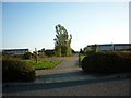
Lakeside on Europarc Industrial Estate
The building ahead is Kerry Foods.
Image: © Steve Fareham
Taken: 24 Nov 2012
0.09 miles
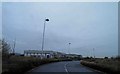
3
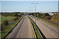
A180 Looking West
Most of the industrial buildings on the right are in TA2411.
Image: © David Wright
Taken: 2 Apr 2006
0.16 miles
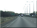
4
A1136 junction from the A180 westbound
Image: © Steve Fareham
Taken: 17 Oct 2012
0.16 miles
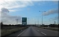
5
A180 west
View west from Woad Lane overbridge
Image: © Richard Croft
Taken: 20 Oct 2010
0.16 miles
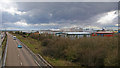
6
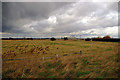
Looking Northeast
As yet undeveloped fields in the foreground.
Image: © David Wright
Taken: 2 Apr 2006
0.23 miles

10
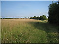
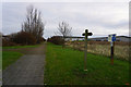
Footpath to Great Coates
A pleasant looking path but the noise from the nearby concrete surfaced A180 is most unpleasant.
Image: © Jonathan Thacker
Taken: 27 Jul 2011
0.24 miles