IMAGES TAKEN NEAR TO
Stockwell, GRIMSBY, DN37 7BN
Introduction
This page details the photographs taken nearby to Stockwell, DN37 7BN by members of the Geograph project.
The Geograph project started in 2005 with the aim of publishing, organising and preserving representative images for every square kilometre of Great Britain, Ireland and the Isle of Man.

There are currently over 7.5m images from over14,400 individuals and you can help contribute to the project by visiting https://www.geograph.org.uk
Image Map (Loading...)


Getting Data...Please wait
Leaflet Map data © OpenStreetMap
Images are licensed for reuse under creativecommons.org/licenses/by-sa/2.0
Notes
- Clicking on the map will re-center to the selected point.
- The higher the marker number, the further away the image location is from the centre of the postcode.
Image Listing (53 Images Found)
Images are licensed for reuse under creativecommons.org/licenses/by-sa/2.0
Image
Details
Distance
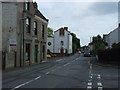
3
Laceby Methodist Church
Closed its doors to worshippers in 2011.
Image: © JThomas
Taken: 5 Jul 2014
0.09 miles
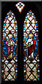
5
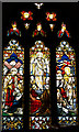
Part of an Anglo-Saxon cross used in the north wall of Laceby Church (3)
See also Image
Image: © Chris
Taken: 6 Jul 2019
0.13 miles
6
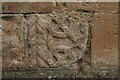
Part of an Anglo-Saxon cross used in the north wall of Laceby Church (2)
See also Image
Image: © Chris
Taken: 6 Jul 2019
0.13 miles
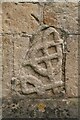
7

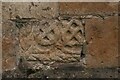
Parts of an Anglo-Saxon cross used in the north wall of Laceby Church (1)
Image: © Chris
Taken: 6 Jul 2019
0.13 miles
9
Part of an Anglo-Saxon cross used in the north wall of Laceby Church (4)
See also Image
Image: © Chris
Taken: 6 Jul 2019
0.13 miles