IMAGES TAKEN NEAR TO
Butterfield Close, GRIMSBY, DN37 7BG
Introduction
This page details the photographs taken nearby to Butterfield Close, DN37 7BG by members of the Geograph project.
The Geograph project started in 2005 with the aim of publishing, organising and preserving representative images for every square kilometre of Great Britain, Ireland and the Isle of Man.

There are currently over 7.5m images from over14,400 individuals and you can help contribute to the project by visiting https://www.geograph.org.uk
Image Map (Loading...)


Getting Data...Please wait
Leaflet Map data © OpenStreetMap
Images are licensed for reuse under creativecommons.org/licenses/by-sa/2.0
Notes
- Clicking on the map will re-center to the selected point.
- The higher the marker number, the further away the image location is from the centre of the postcode.
Image Listing (50 Images Found)
Images are licensed for reuse under creativecommons.org/licenses/by-sa/2.0
Image
Details
Distance
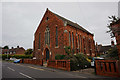
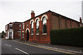
3
Laceby Methodist Church
Closed its doors to worshippers in 2011.
Image: © JThomas
Taken: 5 Jul 2014
0.06 miles
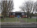
7
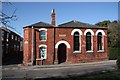
Temperance Hall
Former Temperance Hall in Laceby, now a Community Centre
Image: © Richard Croft
Taken: 2 Mar 2009
0.15 miles
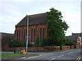
8
Laceby Community Centre
Former Temperance Hall on High Street, Laceby. http://www.geograph.org.uk/photo/5544554
Image: © Ian S
Taken: 20 Sep 2017
0.15 miles
9
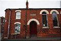
Laceby Community Centre
Former Temperance Hall on High Street, Laceby. http://www.geograph.org.uk/photo/5544556
Image: © Ian S
Taken: 20 Sep 2017
0.15 miles