IMAGES TAKEN NEAR TO
Croxby Road, GRIMSBY, DN37 0SY
Introduction
This page details the photographs taken nearby to Croxby Road, DN37 0SY by members of the Geograph project.
The Geograph project started in 2005 with the aim of publishing, organising and preserving representative images for every square kilometre of Great Britain, Ireland and the Isle of Man.

There are currently over 7.5m images from over14,400 individuals and you can help contribute to the project by visiting https://www.geograph.org.uk
Image Map (Loading...)


Getting Data...Please wait
Leaflet Map data © OpenStreetMap
Images are licensed for reuse under creativecommons.org/licenses/by-sa/2.0
Notes
- Clicking on the map will re-center to the selected point.
- The higher the marker number, the further away the image location is from the centre of the postcode.
Image Listing (28 Images Found)
Images are licensed for reuse under creativecommons.org/licenses/by-sa/2.0
Image
Details
Distance
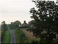
2
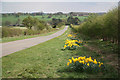
Thorganby Top
View down Croxby Road to Thorganby
Image: © Richard Croft
Taken: 7 Apr 2011
0.05 miles
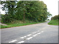
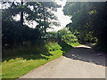
3

The bridleway to Brookenby
Starts promisingly at Thorganby as a farm track but soon changes its nature.
Image: © Jonathan Thacker
Taken: 15 Apr 2011
0.06 miles
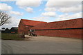
4
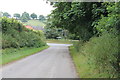
Road Junction at Thorganby
Facing Thorganby House Farm
Image: © J.Hannan-Briggs
Taken: 28 Jul 2013
0.07 miles
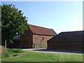
5
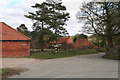
T Junction in Thorganby by Thorganby House Farm
Image: © Chris
Taken: 1 Apr 2013
0.08 miles
7
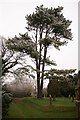
All Saints' churchyard
Frosty view in All Saints' churchyard
Image: © Richard Croft
Taken: 19 Feb 2008
0.08 miles