IMAGES TAKEN NEAR TO
Swinhope Road, GRIMSBY, DN37 0ST
Introduction
This page details the photographs taken nearby to Swinhope Road, DN37 0ST by members of the Geograph project.
The Geograph project started in 2005 with the aim of publishing, organising and preserving representative images for every square kilometre of Great Britain, Ireland and the Isle of Man.

There are currently over 7.5m images from over14,400 individuals and you can help contribute to the project by visiting https://www.geograph.org.uk
Image Map (Loading...)


Getting Data...Please wait
Leaflet Map data © OpenStreetMap
Images are licensed for reuse under creativecommons.org/licenses/by-sa/2.0
Notes
- Clicking on the map will re-center to the selected point.
- The higher the marker number, the further away the image location is from the centre of the postcode.
Image Listing (29 Images Found)
Images are licensed for reuse under creativecommons.org/licenses/by-sa/2.0
Image
Details
Distance
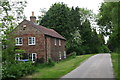
1
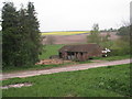
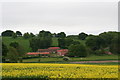
Original farm buildings
These buildings are still being used in the way they were intended. Most of the other barns in Thorganby have been, or are being, converted to houses.
Image: © Jonathan Thacker
Taken: 15 Apr 2011
0.03 miles
3
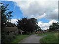
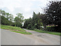
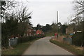
Entering Thorganby
Left turn goes back to Binbrook.
Image: © Chris
Taken: 29 Mar 2013
0.05 miles
4
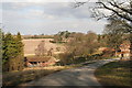
Road junction at Thorganby
Straight on to Swinhope, left to Ravendale
Image: © John Firth
Taken: 5 Jun 2011
0.05 miles
6
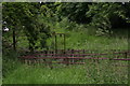
Old sheep pens and weighin facility at Thorganby
Image: © Chris
Taken: 5 Jun 2013
0.07 miles
7
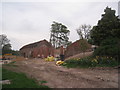
Conversion in progress
Barns in Thorganby being converted into dwellings.
Image: © Jonathan Thacker
Taken: 15 Apr 2011
0.09 miles
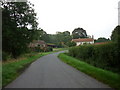
10
The road into Thorganby
And bridge over the stream.
Image: © Chris
Taken: 1 Apr 2013
0.16 miles