IMAGES TAKEN NEAR TO
Thorganby, GRIMSBY, DN37 0SR
Introduction
This page details the photographs taken nearby to DN37 0SR by members of the Geograph project.
The Geograph project started in 2005 with the aim of publishing, organising and preserving representative images for every square kilometre of Great Britain, Ireland and the Isle of Man.

There are currently over 7.5m images from over14,400 individuals and you can help contribute to the project by visiting https://www.geograph.org.uk
Image Map (7 Images)


Getting Data...Please wait
Leaflet Map data © OpenStreetMap
Images are licensed for reuse under creativecommons.org/licenses/by-sa/2.0
Notes
- Clicking on the map will re-center to the selected point.
- The higher the marker number, the further away the image location is from the centre of the postcode.
Image Listing (7 Images Found)
Images are licensed for reuse under creativecommons.org/licenses/by-sa/2.0
Image
Details
Distance
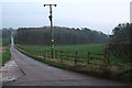
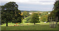
4
Towards Thorganby Hall
Path through the parkland to Thorganby Hall
Image: © Richard Croft
Taken: 23 Feb 2006
0.15 miles
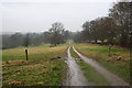
5
Parkland, Thorganby Hall
A fair number of young trees have been planted throughout the park
Image: © Kate Nicol
Taken: 3 Oct 2009
0.21 miles
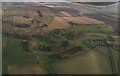
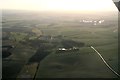
6
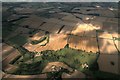
Thorganby: aerial 2016
Image: © Chris
Taken: 21 Aug 2016
0.22 miles
7
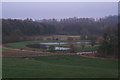
Lake at Thorganby Hall
On a foggy Boxing Day afternoon.
Image: © Chris
Taken: 26 Dec 2013
0.23 miles