IMAGES TAKEN NEAR TO
Hatcliffe, GRIMSBY, DN37 0SP
Introduction
This page details the photographs taken nearby to DN37 0SP by members of the Geograph project.
The Geograph project started in 2005 with the aim of publishing, organising and preserving representative images for every square kilometre of Great Britain, Ireland and the Isle of Man.

There are currently over 7.5m images from over14,400 individuals and you can help contribute to the project by visiting https://www.geograph.org.uk
Image Map (Loading...)


Getting Data...Please wait
Leaflet Map data © OpenStreetMap
Images are licensed for reuse under creativecommons.org/licenses/by-sa/2.0
Notes
- Clicking on the map will re-center to the selected point.
- The higher the marker number, the further away the image location is from the centre of the postcode.
Image Listing (13 Images Found)
Images are licensed for reuse under creativecommons.org/licenses/by-sa/2.0
Image
Details
Distance
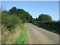
5
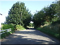
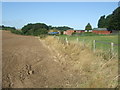
Minor road heading north, Gunnerby
Towards Beelsby.
Image: © JThomas
Taken: 28 Aug 2015
0.09 miles
7
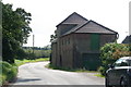
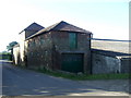
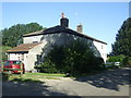
Entrance to Gunnerby House
From Hatcliffe road
Image: © John Firth
Taken: 7 Jun 2011
0.13 miles
8
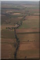
Gunnerby to Hatcliffe and the north: aerial 2016
Image: © Chris
Taken: 5 Jan 2017
0.16 miles
9
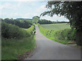
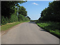
Minor road near Gunnerby House
Heading north west towards Beelsby.
Image: © JThomas
Taken: 28 Aug 2015
0.16 miles