IMAGES TAKEN NEAR TO
Green Lane, GRIMSBY, DN37 0RL
Introduction
This page details the photographs taken nearby to Green Lane, DN37 0RL by members of the Geograph project.
The Geograph project started in 2005 with the aim of publishing, organising and preserving representative images for every square kilometre of Great Britain, Ireland and the Isle of Man.

There are currently over 7.5m images from over14,400 individuals and you can help contribute to the project by visiting https://www.geograph.org.uk
Image Map (Loading...)


Getting Data...Please wait
Leaflet Map data © OpenStreetMap
Images are licensed for reuse under creativecommons.org/licenses/by-sa/2.0
Notes
- Clicking on the map will re-center to the selected point.
- The higher the marker number, the further away the image location is from the centre of the postcode.
Image Listing (77 Images Found)
Images are licensed for reuse under creativecommons.org/licenses/by-sa/2.0
Image
Details
Distance
3
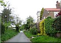
Church Lane Brigsley
St Helen's Church can be seen behind the house on the right
Image: © Martin Dawes
Taken: 29 Apr 2017
0.07 miles
9
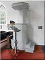
Interior of St Helen, Brigsley
Pulpit with tester/sounding board.
Image: © Dave Hitchborne
Taken: 3 Jun 2004
0.09 miles
10
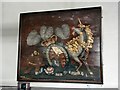
Interior of St Helen, Brigsley
Coat of Arms.
Image: © Dave Hitchborne
Taken: 3 Jun 2004
0.09 miles