IMAGES TAKEN NEAR TO
Summerfield Avenue, GRIMSBY, DN37 0NQ
Introduction
This page details the photographs taken nearby to Summerfield Avenue, DN37 0NQ by members of the Geograph project.
The Geograph project started in 2005 with the aim of publishing, organising and preserving representative images for every square kilometre of Great Britain, Ireland and the Isle of Man.

There are currently over 7.5m images from over14,400 individuals and you can help contribute to the project by visiting https://www.geograph.org.uk
Image Map (Loading...)


Getting Data...Please wait
Leaflet Map data © OpenStreetMap
Images are licensed for reuse under creativecommons.org/licenses/by-sa/2.0
Notes
- Clicking on the map will re-center to the selected point.
- The higher the marker number, the further away the image location is from the centre of the postcode.
Image Listing (13 Images Found)
Images are licensed for reuse under creativecommons.org/licenses/by-sa/2.0
Image
Details
Distance
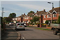
1
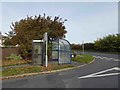
Phone box and bus shelter on the junction of Fairway and Grimsby Road Waltham
Image: © Steve Fareham
Taken: 25 Oct 2015
0.13 miles
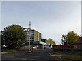
4
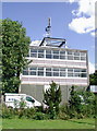
Waltham Telephone Exchange
Telephone exchange building on the east side of Grimsby Road, near the roundabout on the junction of High Street and Station Road, Waltham.
Image: © Paul Glazzard
Taken: 4 Jul 2008
0.18 miles
5
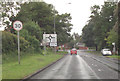
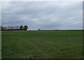
Waltham Road approaching Waltham roundabout
Image: © John Firth
Taken: 16 Jun 2012
0.19 miles
6
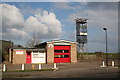
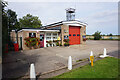
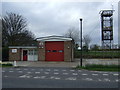
Waltham Fire Station
Manned by retained firefighters
Image: © Richard Croft
Taken: 20 Feb 2006
0.20 miles