IMAGES TAKEN NEAR TO
Fairway, GRIMSBY, DN37 0ND
Introduction
This page details the photographs taken nearby to Fairway, DN37 0ND by members of the Geograph project.
The Geograph project started in 2005 with the aim of publishing, organising and preserving representative images for every square kilometre of Great Britain, Ireland and the Isle of Man.

There are currently over 7.5m images from over14,400 individuals and you can help contribute to the project by visiting https://www.geograph.org.uk
Image Map
Images are licensed for reuse under creativecommons.org/licenses/by-sa/2.0
Notes
- Clicking on the map will re-center to the selected point.
- The higher the marker number, the further away the image location is from the centre of the postcode.
Image Listing (5 Images Found)
Images are licensed for reuse under creativecommons.org/licenses/by-sa/2.0
Image
Details
Distance
1
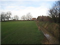
Drain alongside the recreation ground, Waltham
Image: © Jonathan Thacker
Taken: 10 Jan 2014
0.12 miles
2
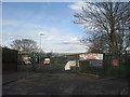
The entrance to Waltham Leas Primary Academy
Image: © Jonathan Thacker
Taken: 10 Jan 2014
0.18 miles
3
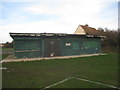
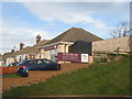
Pavilion, Waltham Recreation Ground
Externally in a poor state.
Image: © Jonathan Thacker
Taken: 10 Jan 2014
0.20 miles
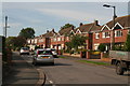
5
Bungalow converted to commercial use
Now a funeral directors' establishment.
Image: © Jonathan Thacker
Taken: 10 Jan 2014
0.25 miles