IMAGES TAKEN NEAR TO
Cheapside, GRIMSBY, DN37 0HT
Introduction
This page details the photographs taken nearby to Cheapside, DN37 0HT by members of the Geograph project.
The Geograph project started in 2005 with the aim of publishing, organising and preserving representative images for every square kilometre of Great Britain, Ireland and the Isle of Man.

There are currently over 7.5m images from over14,400 individuals and you can help contribute to the project by visiting https://www.geograph.org.uk
Image Map (Loading...)


Getting Data...Please wait
Leaflet Map data © OpenStreetMap
Images are licensed for reuse under creativecommons.org/licenses/by-sa/2.0
Notes
- Clicking on the map will re-center to the selected point.
- The higher the marker number, the further away the image location is from the centre of the postcode.
Image Listing (7 Images Found)
Images are licensed for reuse under creativecommons.org/licenses/by-sa/2.0
Image
Details
Distance
1
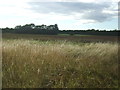
Farmland and hedgerow off Cheapside
Near The Old Nursery.
Image: © JThomas
Taken: 28 Aug 2015
0.06 miles
2
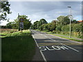
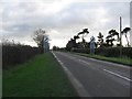
Cheapside
Heading north west towards Waltham
Image: © JThomas
Taken: 28 Aug 2015
0.06 miles
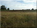
3
Farmland near The Old Nursery
Off Cheapside.
Image: © JThomas
Taken: 28 Aug 2015
0.06 miles
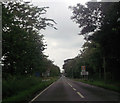
4
The Road To Holton le Clay
From Waltham.
Image: © Roger Gilbertson
Taken: 4 Jan 2007
0.10 miles
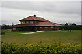
5
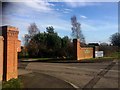
Golf fish and chips ?23-
Entrance to Waltham golf club.
Image: © Steve Fareham
Taken: 18 Feb 2017
0.11 miles