IMAGES TAKEN NEAR TO
Archer Road, GRIMSBY, DN37 0EH
Introduction
This page details the photographs taken nearby to Archer Road, DN37 0EH by members of the Geograph project.
The Geograph project started in 2005 with the aim of publishing, organising and preserving representative images for every square kilometre of Great Britain, Ireland and the Isle of Man.

There are currently over 7.5m images from over14,400 individuals and you can help contribute to the project by visiting https://www.geograph.org.uk
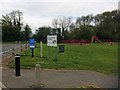
Image Map (Loading...)


Getting Data...Please wait
Leaflet Map data © OpenStreetMap
Images are licensed for reuse under creativecommons.org/licenses/by-sa/2.0
Notes
- Clicking on the map will re-center to the selected point.
- The higher the marker number, the further away the image location is from the centre of the postcode.
Image Listing (42 Images Found)
Images are licensed for reuse under creativecommons.org/licenses/by-sa/2.0
Image
Details
Distance
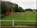
4
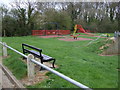
Children's playground, Waltham Recreation Ground
Image: © JThomas
Taken: 12 Apr 2014
0.13 miles
6
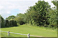
Footpath along spring Head Holt
Hard to see but it's there!
Image: © J.Hannan-Briggs
Taken: 24 Jun 2012
0.13 miles
8
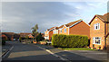
Rosedale, Waltham
The name of the road in this housing estate in the dormitary village in North East Lincolnshire.
Image: © Jonathan Billinger
Taken: 31 Oct 2007
0.14 miles
9
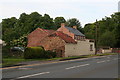
Barns and firewood business in Barnoldby Road, Waltham
Image: © Chris
Taken: 6 Jun 2014
0.16 miles