IMAGES TAKEN NEAR TO
Westfield Road, GRIMSBY, DN37 0DU
Introduction
This page details the photographs taken nearby to Westfield Road, DN37 0DU by members of the Geograph project.
The Geograph project started in 2005 with the aim of publishing, organising and preserving representative images for every square kilometre of Great Britain, Ireland and the Isle of Man.

There are currently over 7.5m images from over14,400 individuals and you can help contribute to the project by visiting https://www.geograph.org.uk
Image Map
Images are licensed for reuse under creativecommons.org/licenses/by-sa/2.0
Notes
- Clicking on the map will re-center to the selected point.
- The higher the marker number, the further away the image location is from the centre of the postcode.
Image Listing (7 Images Found)
Images are licensed for reuse under creativecommons.org/licenses/by-sa/2.0
Image
Details
Distance
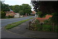
4
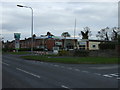
Junction of Barnoldby Road and Birkdale
A large housing development to the north of the main road. Waltham like many other places is now a very large village with all the development
Image: © Martin Dawes
Taken: 29 Apr 2017
0.17 miles