IMAGES TAKEN NEAR TO
Bradley Road, GRIMSBY, DN37 0AW
Introduction
This page details the photographs taken nearby to Bradley Road, DN37 0AW by members of the Geograph project.
The Geograph project started in 2005 with the aim of publishing, organising and preserving representative images for every square kilometre of Great Britain, Ireland and the Isle of Man.

There are currently over 7.5m images from over14,400 individuals and you can help contribute to the project by visiting https://www.geograph.org.uk
Image Map (Loading...)


Getting Data...Please wait
Leaflet Map data © OpenStreetMap
Images are licensed for reuse under creativecommons.org/licenses/by-sa/2.0
Notes
- Clicking on the map will re-center to the selected point.
- The higher the marker number, the further away the image location is from the centre of the postcode.
Image Listing (5 Images Found)
Images are licensed for reuse under creativecommons.org/licenses/by-sa/2.0
Image
Details
Distance
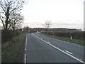
1
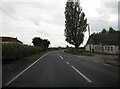
Bradley Road going south passing Netherwood Farm
Image: © Martin Dawes
Taken: 29 Apr 2017
0.02 miles
4
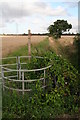
Kissgate, drain, footpath, power lines and lots of bindweed
Greater bindweed (Calystegia sepium - formerly convolvulus) running riot on the gate. See: http://en.wikipedia.org/wiki/Calystegia_sepium
Image: © Chris
Taken: 17 Aug 2014
0.19 miles
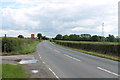
5
Lighting-Up Time
On the road to Bradley from Waltham.
Image: © Roger Gilbertson
Taken: 4 Jan 2007
0.24 miles