IMAGES TAKEN NEAR TO
Seawall Lane, GRIMSBY, DN36 5XE
Introduction
This page details the photographs taken nearby to Seawall Lane, DN36 5XE by members of the Geograph project.
The Geograph project started in 2005 with the aim of publishing, organising and preserving representative images for every square kilometre of Great Britain, Ireland and the Isle of Man.

There are currently over 7.5m images from over14,400 individuals and you can help contribute to the project by visiting https://www.geograph.org.uk
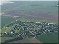
Image Map (Loading...)


Getting Data...Please wait
Leaflet Map data © OpenStreetMap
Images are licensed for reuse under creativecommons.org/licenses/by-sa/2.0
Notes
- Clicking on the map will re-center to the selected point.
- The higher the marker number, the further away the image location is from the centre of the postcode.
Image Listing (15 Images Found)
Images are licensed for reuse under creativecommons.org/licenses/by-sa/2.0
Image
Details
Distance
2
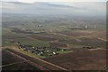
Two windfarms near to North Coates airfield (aerial 2017)
To the right of the "tank farm" (Conoco oil terminal) the two turbines of Newton Marsh are turning whilst a further eight (Bishopthorpe Windfarm) stand ready to be commissioned.
Bottom left is former R.A.F. North Coates, now a sport flying facility.
Image: © Chris
Taken: 29 Jan 2017
0.13 miles
3
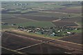
North Coates Airfield: aerial 2017
Bishopthorpe and Newton Marsh windfarms top right in Image
Image: © Chris
Taken: 29 Jan 2017
0.13 miles

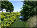
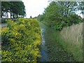
5
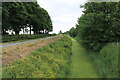
Weed-choked drain at North Coates Airfield
Image: © J.Hannan-Briggs
Taken: 17 Jun 2012
0.19 miles
6
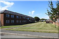
Accommodation blocks at North Cotes
One time barracks for the airmen at RAF North Cotes these have been converted to comfortable flats.
Image: © Adrian S Pye
Taken: 8 Sep 2019
0.19 miles
7
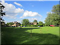
Housing at the former RAF North Coates
Image: © Jonathan Thacker
Taken: 9 Jun 2017
0.21 miles
10
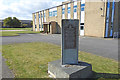
RAF North Cotes Strike Wing memorial
The memorial is difficult to read with the paint flaking, but reads as follows:
"The Royal Air Force / North Cotes Strike Wing./
This memorial commemorates the men / and women who served as pilots, / navigators and ground personnel, / which formed the Royal Air Force / North Cotes Strike Wing / during World War II /
From 1942 to 1945 covering the / coastal regions of Norway, Denmark, / Germany, Holland, Belgium and France / from Bergen to Skagerrak, / the Frisian Islands, the North sea, / the english Channel and / the Bay of Biscay to Bordeaux / operating with Bristol Beaufighter / aircraft, armed with cannon bombs, / torpedo and rockets they inflicted / heavy losses and damage to shipping, / denying freedom of the sea for supply / purposes, for the Nazi German forces / and war industry. /
Over 150,000 tons of enemy shipping / was destroyed. /
These attacks were made by day & / night, flying at very low altitude / in combat conditions of very heavy / German anti-aircraft fire. /
120 aircraft failed to return and / 241 aircrew from Great Britain / the Commonwealth and our allies / gave their lives flying with / The Royal Air Force / North Cotes Strike Wing / (Nos. 143,236 and 254 Squadrons).
Image: © Adrian S Pye
Taken: 8 Sep 2019
0.23 miles