IMAGES TAKEN NEAR TO
Marfleet Corner, GRIMSBY, DN36 5RH
Introduction
This page details the photographs taken nearby to Marfleet Corner, DN36 5RH by members of the Geograph project.
The Geograph project started in 2005 with the aim of publishing, organising and preserving representative images for every square kilometre of Great Britain, Ireland and the Isle of Man.

There are currently over 7.5m images from over14,400 individuals and you can help contribute to the project by visiting https://www.geograph.org.uk
Image Map
Images are licensed for reuse under creativecommons.org/licenses/by-sa/2.0
Notes
- Clicking on the map will re-center to the selected point.
- The higher the marker number, the further away the image location is from the centre of the postcode.
Image Listing (55 Images Found)
Images are licensed for reuse under creativecommons.org/licenses/by-sa/2.0
Image
Details
Distance
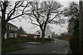
1
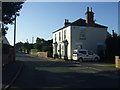
Ludborough Road, North Thoresby
Image for more detail of the house in the photo.
Image: © JThomas
Taken: 28 Aug 2015
0.08 miles
2
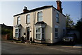
Clifton House on Ludborough Road
North Thoresby.
Image: © Ian S
Taken: 10 Sep 2014
0.08 miles
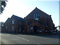
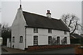
3
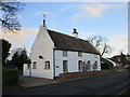
White Cottage and Walnut Cottage
Two cottages formerly one dwelling http://www.britishlistedbuildings.co.uk/en-195352-walnut-cottage-and-adjacent-cottage-nort#.WIMqDVyq-Tw
Image: © Jonathan Thacker
Taken: 20 Jan 2017
0.09 miles
4
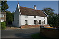
Walnut Cottage on Ludborough Road
North Thoresby.
Image: © Ian S
Taken: 10 Sep 2014
0.09 miles
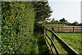
6
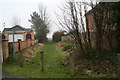
Entrance to the footpath
Off Ludborough Road, North Thoresby.
Image: © Chris
Taken: 8 Mar 2013
0.11 miles