IMAGES TAKEN NEAR TO
Dickinsons Lane, GRIMSBY, DN36 5RG
Introduction
This page details the photographs taken nearby to Dickinsons Lane, DN36 5RG by members of the Geograph project.
The Geograph project started in 2005 with the aim of publishing, organising and preserving representative images for every square kilometre of Great Britain, Ireland and the Isle of Man.

There are currently over 7.5m images from over14,400 individuals and you can help contribute to the project by visiting https://www.geograph.org.uk
Image Map (Loading...)


Getting Data...Please wait
Leaflet Map data © OpenStreetMap
Images are licensed for reuse under creativecommons.org/licenses/by-sa/2.0
Notes
- Clicking on the map will re-center to the selected point.
- The higher the marker number, the further away the image location is from the centre of the postcode.
Image Listing (55 Images Found)
Images are licensed for reuse under creativecommons.org/licenses/by-sa/2.0
Image
Details
Distance
1
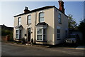
Ludborough Road, North Thoresby
Image for more detail of the house in the photo.
Image: © JThomas
Taken: 28 Aug 2015
0.06 miles
2
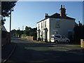
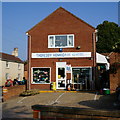
Clifton House on Ludborough Road
North Thoresby.
Image: © Ian S
Taken: 10 Sep 2014
0.07 miles
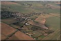
4
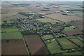
North Thoresby, Station Road: aerial 2017 (1)
The station at the end is operated by Lincolnshire Wolds Railway: see https://lincolnshirewoldsrailway.co.uk/history-of-lwr
Railway (running across the shot) was previously the East Lincolnshire line, operated by the Great Northern Railway Company. In 1923 the latter became part of the London Northern Eastern Railway (LNER), and in 1948 the line became part of British Railways following nationalisation. It closed finally in 1980.
After the last section of line was closed by BR in 1980, the preservation society was formed with the aim of restoring it, and it presently runs to here from Ludborough.
Image: © Chris
Taken: 5 Jan 2017
0.08 miles
8
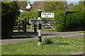
Direction Sign ? Signpost on the B1201 at North Thoresby
Located on the west side of the junction of the B1201 Station Road, High Street and Ludborough Road, in North Thoresby parish. 3 arms but no finial.
Milestone Society National ID: LI_TF2998
Image: © A Riley
Taken: 24 Apr 2022
0.10 miles
10

North Thoresby - 1940s Day 2006
Picture taken in front of Village Hall, 19th August 2006
Image: © David Barnett
Taken: 9 Aug 2006
0.11 miles