IMAGES TAKEN NEAR TO
Robinsons Lane, GRIMSBY, DN36 5QY
Introduction
This page details the photographs taken nearby to Robinsons Lane, DN36 5QY by members of the Geograph project.
The Geograph project started in 2005 with the aim of publishing, organising and preserving representative images for every square kilometre of Great Britain, Ireland and the Isle of Man.

There are currently over 7.5m images from over14,400 individuals and you can help contribute to the project by visiting https://www.geograph.org.uk
Image Map (Loading...)


Getting Data...Please wait
Leaflet Map data © OpenStreetMap
Images are licensed for reuse under creativecommons.org/licenses/by-sa/2.0
Notes
- Clicking on the map will re-center to the selected point.
- The higher the marker number, the further away the image location is from the centre of the postcode.
Image Listing (64 Images Found)
Images are licensed for reuse under creativecommons.org/licenses/by-sa/2.0
Image
Details
Distance
4
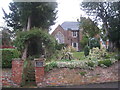
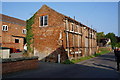
Mapletoft, North Thoresby
A private house, but built as a school by the Mapletoft Trust. The school closed in 1889, as a result of losing its certificate of efficiency due to falling standards of attainment, but the Trust continues. It was created as a result of the will of Dr. Robert Mapletoft http://en.wikipedia.org/wiki/Robert_Mapletoft
Image: © Jonathan Thacker
Taken: 3 Nov 2012
0.11 miles
5
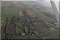
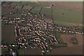
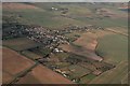
North Thoresby, Station Road: aerial 2017 (1)
The station at the end is operated by Lincolnshire Wolds Railway: see https://lincolnshirewoldsrailway.co.uk/history-of-lwr
Railway (running across the shot) was previously the East Lincolnshire line, operated by the Great Northern Railway Company. In 1923 the latter became part of the London Northern Eastern Railway (LNER), and in 1948 the line became part of British Railways following nationalisation. It closed finally in 1980.
After the last section of line was closed by BR in 1980, the preservation society was formed with the aim of restoring it, and it presently runs to here from Ludborough.
Image: © Chris
Taken: 5 Jan 2017
0.11 miles
6
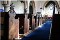
Bench Ends in St.Helen's church
Early 16th century bench ends bearing the initials of their donors
Image: © Richard Croft
Taken: 4 Apr 2006
0.12 miles
7
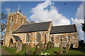
St.Helen's church, North Thoresby, Lincs.
Early English, Decorated & Perpendicular with some fascinating early 16th century bench ends
Image: © Richard Croft
Taken: 4 Apr 2006
0.12 miles
9
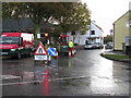
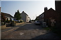
A dreary morning in North Thoresby Square
They were mending a water main and it was raining to add to the damp.
Image: © Bob Emm
Taken: 31 Oct 2008
0.13 miles