IMAGES TAKEN NEAR TO
Market Place, GRIMSBY, DN36 5NN
Introduction
This page details the photographs taken nearby to Market Place, DN36 5NN by members of the Geograph project.
The Geograph project started in 2005 with the aim of publishing, organising and preserving representative images for every square kilometre of Great Britain, Ireland and the Isle of Man.

There are currently over 7.5m images from over14,400 individuals and you can help contribute to the project by visiting https://www.geograph.org.uk
Image Map
Images are licensed for reuse under creativecommons.org/licenses/by-sa/2.0
Notes
- Clicking on the map will re-center to the selected point.
- The higher the marker number, the further away the image location is from the centre of the postcode.
Image Listing (72 Images Found)
Images are licensed for reuse under creativecommons.org/licenses/by-sa/2.0
Image
Details
Distance

7
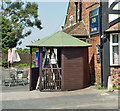
Smoking Shelter at the Plough Inn, Tetney
A new feature since this public house was first Geographed in September 2006 Image
Image: © David Wright
Taken: 25 Jul 2008
0.01 miles
8
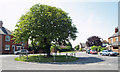
Tetney
Photo taken near the Plough Inn looking across the A1031 towards Town Road.
Image: © David Wright
Taken: 25 Jul 2008
0.01 miles
10
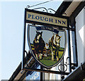
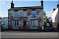
The Sign of the Plough Inn, Tetney
The Plough Inn Image is situated at the junction of Town Road and the A1031.
Image: © David Wright
Taken: 25 Jul 2008
0.02 miles