IMAGES TAKEN NEAR TO
DN36 5JW
Introduction
This page details the photographs taken nearby to DN36 5JW by members of the Geograph project.
The Geograph project started in 2005 with the aim of publishing, organising and preserving representative images for every square kilometre of Great Britain, Ireland and the Isle of Man.

There are currently over 7.5m images from over14,400 individuals and you can help contribute to the project by visiting https://www.geograph.org.uk
Image Map (Loading...)


Getting Data...Please wait
Leaflet Map data © OpenStreetMap
Images are licensed for reuse under creativecommons.org/licenses/by-sa/2.0
Notes
- Clicking on the map will re-center to the selected point.
- The higher the marker number, the further away the image location is from the centre of the postcode.
Image Listing (5 Images Found)
Images are licensed for reuse under creativecommons.org/licenses/by-sa/2.0
Image
Details
Distance
4
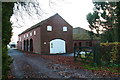
Second Holme Farm
In Grainsby Lane.
Some nice brick barns and waggon hovels.
Image: © Chris
Taken: 17 Nov 2012
0.21 miles
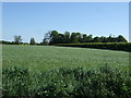
5
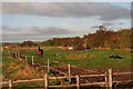
Autumn- and other colours at the horse field on Thoresby Road
Image: © Chris
Taken: 27 Oct 2012
0.24 miles