IMAGES TAKEN NEAR TO
Church View, GRIMSBY, DN36 5JS
Introduction
This page details the photographs taken nearby to Church View, DN36 5JS by members of the Geograph project.
The Geograph project started in 2005 with the aim of publishing, organising and preserving representative images for every square kilometre of Great Britain, Ireland and the Isle of Man.

There are currently over 7.5m images from over14,400 individuals and you can help contribute to the project by visiting https://www.geograph.org.uk
Image Map
Images are licensed for reuse under creativecommons.org/licenses/by-sa/2.0
Notes
- Clicking on the map will re-center to the selected point.
- The higher the marker number, the further away the image location is from the centre of the postcode.
Image Listing (68 Images Found)
Images are licensed for reuse under creativecommons.org/licenses/by-sa/2.0
Image
Details
Distance
4
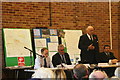
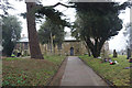
Tetney Village Hall anti-windfarm meeting, 27th October 2012
250 people attend a meeting to discuss the proliferation of windfarms around Tetney and on this strip of land east of the Lincolnshire Wolds, and stretching from the Humber to the Wash.
Five are under construction or planned within about a mile of Tetney alone, and now many of the people of this area, supported by Lincolnshire County Council, have said enough is enough, but it is difficult for the Planning Committee to refuse the applications whilst the government is in favour of them, and prepared to offer large subsidies.
Local MP Mr.Peter Tapsell (standing) was one of the speakers.
Image: © Chris
Taken: 27 Oct 2012
0.06 miles
6
Tetney Village Hall anti-windfarm meeting, 27th October 2012
250 people attend a meeting to discuss the proliferation of windfarms around Tetney and on this strip of land east of the Lincolnshire Wolds, and stretching from the Humber to the Wash.
Five are under construction or planned within about a mile of Tetney alone, and now many of the people of this area, supported by Lincolnshire County Council, have said enough is enough, but it is difficult for the Planning Committee to refuse the applications whilst the government is in favour of them, and prepared to offer large subsidies.
Local MP Mr.Peter Tapsell was one of the speakers.
Image: © Chris
Taken: 27 Oct 2012
0.07 miles
7

Tetney Village Hall anti-windfarm meeting, 27th October 2012
250 people attend a meeting to discuss the proliferation of windfarms around Tetney and on this strip of land east of the Lincolnshire Wolds, and stretching from the Humber to the Wash.
Five are under construction or planned within about a mile of Tetney alone, and now many of the people of this area, supported by Lincolnshire County Council, have said enough is enough, but it is difficult for the Planning Committee to refuse the applications whilst the government is in favour of them, and prepared to offer large subsidies.
Local MP Mr.Peter Tapsell was one of the speakers.
Image: © Chris
Taken: 27 Oct 2012
0.07 miles
8
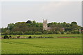
Tetney Church from Outholme Lane
Viewed across a field of barley. The rough area in the centre is the site of blow well. There are many of these in the area, including the "Tetney Blow Wells" site just out of shot to the right - see Image
Image: © Chris
Taken: 12 May 2014
0.07 miles
10
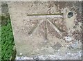
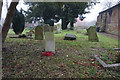
Ordnance Survey 1GL Bolt
This OS Bolt can be found on the north face of St Peter & St Paul's Church. It marks a point 7.100m above mean sea level.
Image: © Adrian Dust
Taken: 25 Jul 2017
0.07 miles