IMAGES TAKEN NEAR TO
Thoresby Road, GRIMSBY, DN36 5JN
Introduction
This page details the photographs taken nearby to Thoresby Road, DN36 5JN by members of the Geograph project.
The Geograph project started in 2005 with the aim of publishing, organising and preserving representative images for every square kilometre of Great Britain, Ireland and the Isle of Man.

There are currently over 7.5m images from over14,400 individuals and you can help contribute to the project by visiting https://www.geograph.org.uk
Image Map (Loading...)


Getting Data...Please wait
Leaflet Map data © OpenStreetMap
Images are licensed for reuse under creativecommons.org/licenses/by-sa/2.0
Notes
- Clicking on the map will re-center to the selected point.
- The higher the marker number, the further away the image location is from the centre of the postcode.
Image Listing (17 Images Found)
Images are licensed for reuse under creativecommons.org/licenses/by-sa/2.0
Image
Details
Distance
1
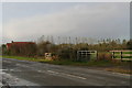
New development on Thoresby Road
Replaces an old brick cottage. There is a new pond, along the edge of which is the line of young willow trees.
Image: © Chris
Taken: 27 Oct 2012
0.02 miles
2
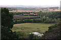
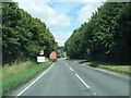
Road from Tetney to North Thoresby, from the church tower
Image: © Chris
Taken: 18 Sep 2013
0.03 miles
3

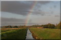
Rainbow over Waithe Beck bridge
Not sure which square on the map the rainbow is in!
Image: © Chris
Taken: 27 Oct 2012
0.08 miles
4
Waithe Beck bank after the rain
Looking east towards the wood which contains the Tetney Blow Wells.
Image: © Chris
Taken: 27 Oct 2012
0.12 miles
5
Autumn- and other colours at the horse field on Thoresby Road
Image: © Chris
Taken: 27 Oct 2012
0.13 miles
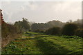
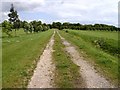
8
18 holes to Waithe
The footpath passes through the length of Tetney golf course, and a couple of keen players continue their round about to hit their shots to the green on the left. Although the scene was pleasant enough, large drop of rain were falling at the time.
Image: © John Beal
Taken: 19 May 2007
0.16 miles
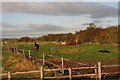
10
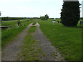
The rain has passed
A little further along the path from Image looking in the opposite direction. The land drain on the right feeds into Waithe Beck.
Image: © John Beal
Taken: 19 May 2007
0.18 miles