IMAGES TAKEN NEAR TO
Pinfold Lane, GRIMSBY, DN36 5DH
Introduction
This page details the photographs taken nearby to Pinfold Lane, DN36 5DH by members of the Geograph project.
The Geograph project started in 2005 with the aim of publishing, organising and preserving representative images for every square kilometre of Great Britain, Ireland and the Isle of Man.

There are currently over 7.5m images from over14,400 individuals and you can help contribute to the project by visiting https://www.geograph.org.uk
Image Map
Images are licensed for reuse under creativecommons.org/licenses/by-sa/2.0
Notes
- Clicking on the map will re-center to the selected point.
- The higher the marker number, the further away the image location is from the centre of the postcode.
Image Listing (43 Images Found)
Images are licensed for reuse under creativecommons.org/licenses/by-sa/2.0
Image
Details
Distance
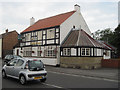
1
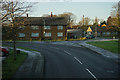
Pinfold Lane at St Peter's Close, Holton le Clay
Image: © Ian S
Taken: 18 Dec 2017
0.01 miles
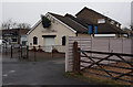
5
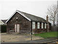
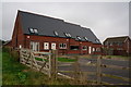
Disused hall, Holton le Clay
A prefabricted building once a common sight but now increasingly rare. No doubt before long this will be replaced by housing.
Image: © Jonathan Thacker
Taken: 1 Feb 2018
0.09 miles