IMAGES TAKEN NEAR TO
Fenwick Court, GRIMSBY, DN36 5DG
Introduction
This page details the photographs taken nearby to Fenwick Court, DN36 5DG by members of the Geograph project.
The Geograph project started in 2005 with the aim of publishing, organising and preserving representative images for every square kilometre of Great Britain, Ireland and the Isle of Man.

There are currently over 7.5m images from over14,400 individuals and you can help contribute to the project by visiting https://www.geograph.org.uk
Image Map (Loading...)


Getting Data...Please wait
Leaflet Map data © OpenStreetMap
Images are licensed for reuse under creativecommons.org/licenses/by-sa/2.0
Notes
- Clicking on the map will re-center to the selected point.
- The higher the marker number, the further away the image location is from the centre of the postcode.
Image Listing (18 Images Found)
Images are licensed for reuse under creativecommons.org/licenses/by-sa/2.0
Image
Details
Distance

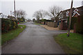
2
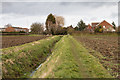
Footpath to Holton le Clay
Looking NNE along the footpath from Station Road as it enters Holton le Clay on Louth Road.
Image: © David P Howard
Taken: 6 Mar 2016
0.10 miles
3

Holton le Clay to Grimsby: aerial 2017
New Waltham and Humberston lie between Holton le Clay and Grimsby.
Village is between the A16 and the disused railway. Heritage railway operates on part of the track (Lincolnshire Wolds Railway: see https://lincolnshirewoldsrailway.co.uk/history-of-lwr) but the section north of Holton le Clay has been used to construct a "fast road" into Grimsby.
Railway was previously the East Lincolnshire line, operated by the Great Northern Railway Company. In 1923 the latter became part of the London Northern Eastern Railway (LNER), and in 1948 the line became part of British Railways following nationalisation. It closed finally in 1980.
After the last section of line was closed by BR in 1980, the preservation society was formed with the aim of restoring it.
Image: © Chris
Taken: 5 Jan 2017
0.14 miles