IMAGES TAKEN NEAR TO
Ashby Close, GRIMSBY, DN36 5BD
Introduction
This page details the photographs taken nearby to Ashby Close, DN36 5BD by members of the Geograph project.
The Geograph project started in 2005 with the aim of publishing, organising and preserving representative images for every square kilometre of Great Britain, Ireland and the Isle of Man.

There are currently over 7.5m images from over14,400 individuals and you can help contribute to the project by visiting https://www.geograph.org.uk
Image Map
Images are licensed for reuse under creativecommons.org/licenses/by-sa/2.0
Notes
- Clicking on the map will re-center to the selected point.
- The higher the marker number, the further away the image location is from the centre of the postcode.
Image Listing (10 Images Found)
Images are licensed for reuse under creativecommons.org/licenses/by-sa/2.0
Image
Details
Distance
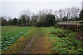
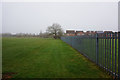
1
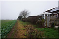
Path leading to Magnolia Drive, Holton le Clay
Image: © Ian S
Taken: 22 Dec 2017
0.08 miles
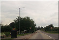
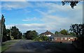
4

A very straight Holton Road leaving Holton le Clay
Image: © Steve Fareham
Taken: 22 Jun 2013
0.15 miles
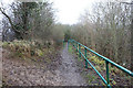
6
Path leading to Magnolia Drive, Holton le Clay
Image: © Ian S
Taken: 22 Dec 2017
0.18 miles
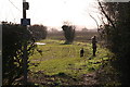
9
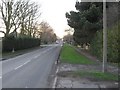
Tetney Lane
From Holton le Clay to Tetney.
Image: © Roger Gilbertson
Taken: 4 Jan 2007
0.22 miles
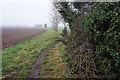
10
Path leading to Magnolia Drive, Holton le Clay
Image: © Ian S
Taken: 22 Dec 2017
0.25 miles