IMAGES TAKEN NEAR TO
Crofters Grove, GRIMSBY, DN36 4WL
Introduction
This page details the photographs taken nearby to Crofters Grove, DN36 4WL by members of the Geograph project.
The Geograph project started in 2005 with the aim of publishing, organising and preserving representative images for every square kilometre of Great Britain, Ireland and the Isle of Man.

There are currently over 7.5m images from over14,400 individuals and you can help contribute to the project by visiting https://www.geograph.org.uk
Image Map
Images are licensed for reuse under creativecommons.org/licenses/by-sa/2.0
Notes
- Clicking on the map will re-center to the selected point.
- The higher the marker number, the further away the image location is from the centre of the postcode.
Image Listing (16 Images Found)
Images are licensed for reuse under creativecommons.org/licenses/by-sa/2.0
Image
Details
Distance
1
Maple Drive, New Waltham
The end of this Cul-de-Sac residential road is in TA2804 whilst the rest is in TA2704.
Image: © David Wright
Taken: 25 Jul 2008
0.13 miles
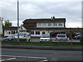
3
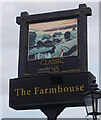
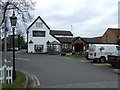
Farmhouse public house on Station Road, New Waltham
Image: © Ian S
Taken: 2 Sep 2020
0.14 miles
4
Farmhouse public house on Station Road, New Waltham
Image: © Ian S
Taken: 2 Sep 2020
0.14 miles
5
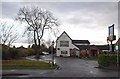
The Farmhouse pub, New Waltham
On Station Road.
Image: © JThomas
Taken: 12 Apr 2014
0.15 miles
7
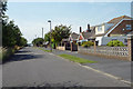
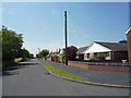
Maple Drive, New Waltham
Only the northern side of Maple Drive is at present built-up. The other side of the street is still open fields.
Image: © David Wright
Taken: 25 Jul 2008
0.18 miles
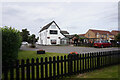
9
The Harvest Moon pub, New Waltham
On Station Road.
Image: © JThomas
Taken: 12 Apr 2014
0.19 miles
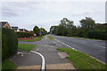
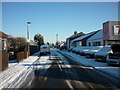
10
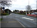
Mini roundabout on Station Road, New Waltham
Looking east.
Image: © JThomas
Taken: 12 Apr 2014
0.21 miles