IMAGES TAKEN NEAR TO
Vickers Road, DN36 4UT
Introduction
This page details the photographs taken nearby to Vickers Road, DN36 4UT by members of the Geograph project.
The Geograph project started in 2005 with the aim of publishing, organising and preserving representative images for every square kilometre of Great Britain, Ireland and the Isle of Man.

There are currently over 7.5m images from over14,400 individuals and you can help contribute to the project by visiting https://www.geograph.org.uk
Image Map (Loading...)


Getting Data...Please wait
Leaflet Map data © OpenStreetMap
Images are licensed for reuse under creativecommons.org/licenses/by-sa/2.0
Notes
- Clicking on the map will re-center to the selected point.
- The higher the marker number, the further away the image location is from the centre of the postcode.
Image Listing (9 Images Found)
Images are licensed for reuse under creativecommons.org/licenses/by-sa/2.0
Image
Details
Distance
1
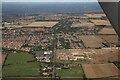
New development by Tollbar Roundabout, A16, Grimsby: aerial 2023
Image: © Chris
Taken: 20 Aug 2023
0.07 miles
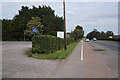
2
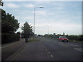
Station Road outside Tollbar School
Viewed from layby outside school looking towards A16
Image: © John Firth
Taken: 11 Jul 2011
0.09 miles
4
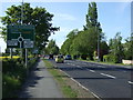
A16 approaching Toll Bar Roundabout
Towards Grimsby.
Image: © JThomas
Taken: 25 May 2013
0.17 miles
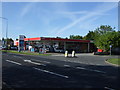
6

Esso Petrol Station
This petrol station is situated at the corner of Louth Road (A16T) and Maple Grove. When the photo was taken Unleaded was 117.9p per litre and Diesel 130.9p.
Image: © David Wright
Taken: 25 Jul 2008
0.22 miles