IMAGES TAKEN NEAR TO
Field House Road, GRIMSBY, DN36 4TL
Introduction
This page details the photographs taken nearby to Field House Road, DN36 4TL by members of the Geograph project.
The Geograph project started in 2005 with the aim of publishing, organising and preserving representative images for every square kilometre of Great Britain, Ireland and the Isle of Man.

There are currently over 7.5m images from over14,400 individuals and you can help contribute to the project by visiting https://www.geograph.org.uk
Image Map
Images are licensed for reuse under creativecommons.org/licenses/by-sa/2.0
Notes
- Clicking on the map will re-center to the selected point.
- The higher the marker number, the further away the image location is from the centre of the postcode.
Image Listing (9 Images Found)
Images are licensed for reuse under creativecommons.org/licenses/by-sa/2.0
Image
Details
Distance
1
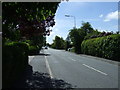
Church Avenue (A1031), heading south
Towards Mablethorpe.
Image: © JThomas
Taken: 25 May 2013
0.16 miles
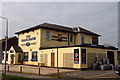
3
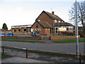
The Countryman Public House
On the corner of Lidgard Road, close to the Fieldhouse Shopping Precinct, Humberston.
Image: © Roger Gilbertson
Taken: 4 Jan 2007
0.21 miles
5
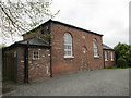
The Wendover Hall
Humberston's village hall. Dates from 1909.
Image: © Jonathan Thacker
Taken: 13 May 2016
0.21 miles
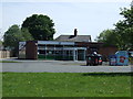
6
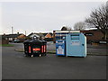
Humberston Library and Recycling Point
Image: © Alan Heardman
Taken: 29 Nov 2009
0.22 miles
7
The Coach House
Formerly Fieldhouse Farm. This has been a pub for a long time now. It is however one of the key farmhouses which made up the Carrington estate in the nineteenth century.
Image: © Jon Holland
Taken: 3 Apr 2008
0.23 miles
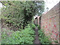
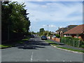
9
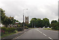
Bend in road in Humberstone
Looking south, the church can be seen
Image: © John Firth
Taken: 14 Jun 2012
0.25 miles