IMAGES TAKEN NEAR TO
Humberston Fitties, GRIMSBY, DN36 4HA
Introduction
This page details the photographs taken nearby to Humberston Fitties, DN36 4HA by members of the Geograph project.
The Geograph project started in 2005 with the aim of publishing, organising and preserving representative images for every square kilometre of Great Britain, Ireland and the Isle of Man.

There are currently over 7.5m images from over14,400 individuals and you can help contribute to the project by visiting https://www.geograph.org.uk
Image Map (Loading...)


Getting Data...Please wait
Leaflet Map data © OpenStreetMap
Images are licensed for reuse under creativecommons.org/licenses/by-sa/2.0
Notes
- Clicking on the map will re-center to the selected point.
- The higher the marker number, the further away the image location is from the centre of the postcode.
Image Listing (39 Images Found)
Images are licensed for reuse under creativecommons.org/licenses/by-sa/2.0
Image
Details
Distance
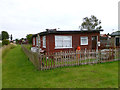
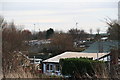
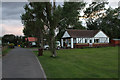
2
Chalets behind the sea bank at Humberston Fitties
These chalets now have an unsolicited view of the new Newton Marsh windfarm under construction.
'Fitties' is a local word meaning 'salt marsh'. The Humberston Fitties were originally one of a number of fitties along this part of the coastline.
The Humberston Fitties developed when the area was divided up into plots of different sizes during the 1920's. These areas became known as plot lands. During the First World War the coastal area was used for billeting soldiers who were stationed in the nearby Haile Sands Fort.
After the war a local family set up a tent so they could have access to fresh air to combat ill health. The following year they erected a chalet and after the soldiers were demobbed other people moved in with tents or into the original camp huts used by the soldiers.
More holidaymakers arrived bringing their own accommodation in the form of caravans, buses and old railway carriages. As the area developed holiday chalets were built on stilts and wheels because the area was prone to flooding.
See: http://www.nelincs.gov.uk/resident/arts--events-and-tourism/humberston-fitties/history-humberston-fitties/
Image: © Chris
Taken: 7 Feb 2013
0.05 miles
5
Chalets behind the bank at Humberston Fitties
These chalets now have an unsolicited view of the new Newton Marsh windfarm under construction.
'Fitties' is a local word meaning 'salt marsh'. The Humberston Fitties were originally one of a number of fitties along this part of the coastline.
The Humberston Fitties developed when the area was divided up into plots of different sizes during the 1920's. These areas became known as plot lands. During the First World War the coastal area was used for billeting soldiers who were stationed in the nearby Haile Sands Fort.
After the war a local family set up a tent so they could have access to fresh air to combat ill health. The following year they erected a chalet and after the soldiers were demobbed other people moved in with tents or into the original camp huts used by the soldiers.
More holidaymakers arrived bringing their own accommodation in the form of caravans, buses and old railway carriages. As the area developed holiday chalets were built on stilts and wheels because the area was prone to flooding.
See: http://www.nelincs.gov.uk/resident/arts--events-and-tourism/humberston-fitties/history-humberston-fitties/
Image: © Chris
Taken: 7 Feb 2013
0.06 miles
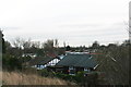
6
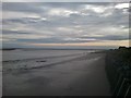
Cleethorpes Beach
View taken on Cleethorpes beach behind Humberston Fitties.
Image: © claire
Taken: 28 Oct 2014
0.07 miles
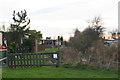
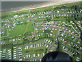
7
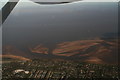
Humberston Fitties, Thorpe Park and Spurn Point: aerial 2016
I have not cropped the top so as to leave Spurn Point in shot.
Image: © Chris
Taken: 13 Nov 2016
0.08 miles
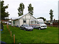
8
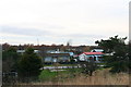
Chalets at Humberston Fitties
'Fitties' is a local word meaning 'salt marsh'. The Humberston Fitties were originally one of a number of fitties along this part of the coastline.
The Humberston Fitties developed when the area was divided up into plots of different sizes during the 1920's. These areas became known as plot lands. During the First World War the coastal area was used for billeting soldiers who were stationed in the nearby Haile Sands Fort.
After the war a local family set up a tent so they could have access to fresh air to combat ill health. The following year they erected a chalet and after the soldiers were demobbed other people moved in with tents or into the original camp huts used by the soldiers.
More holidaymakers arrived bringing their own accommodation in the form of caravans, buses and old railway carriages. As the area developed holiday chalets were built on stilts and wheels because the area was prone to flooding.
See: http://www.nelincs.gov.uk/resident/arts--events-and-tourism/humberston-fitties/history-humberston-fitties/
Image: © Chris
Taken: 7 Feb 2013
0.09 miles
10
Humberston Fitties 1 (aerial), 2007
'Fitties' is a local word meaning 'salt marsh'. The Humberston Fitties were originally one of a number of fitties along this part of the coastline.
The Humberston Fitties developed when the area was divided up into plots of different sizes during the 1920's. These areas became known as plot lands. During the First World War the coastal area was used for billeting soldiers who were stationed in the nearby Haile Sands Fort.
After the war a local family set up a tent so they could have access to fresh air to combat ill health. The following year they erected a chalet and after the soldiers were demobbed other people moved in with tents or into the original camp huts used by the soldiers.
More holidaymakers arrived bringing their own accommodation in the form of caravans, buses and old railway carriages. As the area developed holiday chalets were built on stilts and wheels because the area was prone to flooding.
In 1938 the land ownership was passed to the local authority. This has allowed us to preserve this unique area when other similar private plot lands have been gradually sold off for development over the years. During World War II the chalets were again returned to military duty, and it is believed that a decoy representing Grimsby Docks was erected nearby.
http://www.nelincs.gov.uk/resident/arts--events-and-tourism/humberston-fitties/history-humberston-fitties/; http://www.humberstonchalet.co.uk/old/htm/history.asp
Image: © John Hardy
Taken: 8 Aug 2007
0.10 miles