IMAGES TAKEN NEAR TO
Arran Close, GRIMSBY, DN36 4GX
Introduction
This page details the photographs taken nearby to Arran Close, DN36 4GX by members of the Geograph project.
The Geograph project started in 2005 with the aim of publishing, organising and preserving representative images for every square kilometre of Great Britain, Ireland and the Isle of Man.

There are currently over 7.5m images from over14,400 individuals and you can help contribute to the project by visiting https://www.geograph.org.uk
Image Map
Images are licensed for reuse under creativecommons.org/licenses/by-sa/2.0
Notes
- Clicking on the map will re-center to the selected point.
- The higher the marker number, the further away the image location is from the centre of the postcode.
Image Listing (9 Images Found)
Images are licensed for reuse under creativecommons.org/licenses/by-sa/2.0
Image
Details
Distance
1
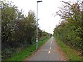
Cycle way following the former railway line from Louth to Grimsby
Image: © Steve Fareham
Taken: 12 Oct 2015
0.01 miles
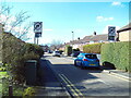
3
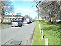
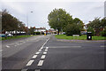
South end of Peaks Avenue, New Waltham
Alongside the village green (right), with New Waltham Academy visible ahead on the left.
Image: © Richard Vince
Taken: 24 Feb 2024
0.22 miles
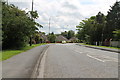
5
Peaks Lane, New Waltham
Looking towards Cleethorpes as it passes the village green (left).
Image: © Richard Vince
Taken: 24 Feb 2024
0.23 miles
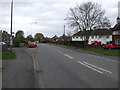
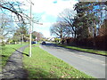
6
Holme Avenue, New Waltham
Off the very south end of Peaks Avenue, close to its junction with Peaks Lane. Despite the narrow width of the pavements, the ban on cars parking partly on the pavement does not apply on this road.
Image: © Richard Vince
Taken: 24 Feb 2024
0.23 miles