IMAGES TAKEN NEAR TO
Humberston Fitties, GRIMSBY, DN36 4EU
Introduction
This page details the photographs taken nearby to Humberston Fitties, DN36 4EU by members of the Geograph project.
The Geograph project started in 2005 with the aim of publishing, organising and preserving representative images for every square kilometre of Great Britain, Ireland and the Isle of Man.

There are currently over 7.5m images from over14,400 individuals and you can help contribute to the project by visiting https://www.geograph.org.uk
Image Map
Images are licensed for reuse under creativecommons.org/licenses/by-sa/2.0
Notes
- Clicking on the map will re-center to the selected point.
- The higher the marker number, the further away the image location is from the centre of the postcode.
Image Listing (50 Images Found)
Images are licensed for reuse under creativecommons.org/licenses/by-sa/2.0
Image
Details
Distance
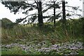
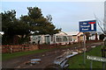
1
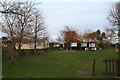
Chalets at Humberston Fitties
The chalets are not cleared for full-time residential use, but the fight is on to allow 50-weeks-per-year use so that the owners can spend some time there in the winter.
'Fitties' is a local word meaning 'salt marsh'. The Humberston Fitties were originally one of a number of fitties along this part of the coastline.
The Humberston Fitties developed when the area was divided up into plots of different sizes during the 1920's. These areas became known as plot lands. During the First World War the coastal area was used for billeting soldiers who were stationed in the nearby Haile Sands Fort.
After the war a local family set up a tent so they could have access to fresh air to combat ill health. The following year they erected a chalet and after the soldiers were demobbed other people moved in with tents or into the original camp huts used by the soldiers.
More holidaymakers arrived bringing their own accommodation in the form of caravans, buses and old railway carriages. As the area developed holiday chalets were built on stilts and wheels because the area was prone to flooding.
See: http://www.nelincs.gov.uk/resident/arts--events-and-tourism/humberston-fitties/history-humberston-fitties/
Image: © Chris
Taken: 7 Feb 2013
0.02 miles
2
Chalets at Humberston Fitties
The chalets are not cleared for full-time residential use, but the fight is on to allow 50-weeks-per-year use so that the owners can spend some time there in the winter.
'Fitties' is a local word meaning 'salt marsh'. The Humberston Fitties were originally one of a number of fitties along this part of the coastline.
The Humberston Fitties developed when the area was divided up into plots of different sizes during the 1920's. These areas became known as plot lands. During the First World War the coastal area was used for billeting soldiers who were stationed in the nearby Haile Sands Fort.
After the war a local family set up a tent so they could have access to fresh air to combat ill health. The following year they erected a chalet and after the soldiers were demobbed other people moved in with tents or into the original camp huts used by the soldiers.
More holidaymakers arrived bringing their own accommodation in the form of caravans, buses and old railway carriages. As the area developed holiday chalets were built on stilts and wheels because the area was prone to flooding.
See: http://www.nelincs.gov.uk/resident/arts--events-and-tourism/humberston-fitties/history-humberston-fitties/
Image: © Chris
Taken: 7 Feb 2013
0.05 miles
3
Chalets at Humberston Fitties
The chalets are not cleared for full-time residential use, but the fight is on to allow 50-weeks-per-year use so that the owners can spend some time there in the winter.
'Fitties' is a local word meaning 'salt marsh'. The Humberston Fitties were originally one of a number of fitties along this part of the coastline.
The Humberston Fitties developed when the area was divided up into plots of different sizes during the 1920's. These areas became known as plot lands. During the First World War the coastal area was used for billeting soldiers who were stationed in the nearby Haile Sands Fort.
After the war a local family set up a tent so they could have access to fresh air to combat ill health. The following year they erected a chalet and after the soldiers were demobbed other people moved in with tents or into the original camp huts used by the soldiers.
More holidaymakers arrived bringing their own accommodation in the form of caravans, buses and old railway carriages. As the area developed holiday chalets were built on stilts and wheels because the area was prone to flooding.
See: http://www.nelincs.gov.uk/resident/arts--events-and-tourism/humberston-fitties/history-humberston-fitties/
Image: © Chris
Taken: 7 Feb 2013
0.05 miles
4
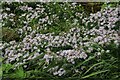
Michaelmas daisies in Humberston Fitties (2)
Close tothe beach, but not Sea Asters.
Image: © Chris
Taken: 1 Oct 2023
0.05 miles
5
Michaelmas daisies in Humberston Fitties (1)
Under the Scots Pines.
Image: © Chris
Taken: 1 Oct 2023
0.05 miles
6
Chalets at Humberston Fitties
'Fitties' is a local word meaning 'salt marsh'. The Humberston Fitties were originally one of a number of fitties along this part of the coastline.
The Humberston Fitties developed when the area was divided up into plots of different sizes during the 1920's. These areas became known as plot lands. During the First World War the coastal area was used for billeting soldiers who were stationed in the nearby Haile Sands Fort.
After the war a local family set up a tent so they could have access to fresh air to combat ill health. The following year they erected a chalet and after the soldiers were demobbed other people moved in with tents or into the original camp huts used by the soldiers.
More holidaymakers arrived bringing their own accommodation in the form of caravans, buses and old railway carriages. As the area developed holiday chalets were built on stilts and wheels because the area was prone to flooding.
See: http://www.nelincs.gov.uk/resident/arts--events-and-tourism/humberston-fitties/history-humberston-fitties/
Image: © Chris
Taken: 7 Feb 2013
0.06 miles
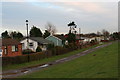
9
4th Avenue, Humberston Fitties
'Fitties' is a local word meaning 'salt marsh'. The Humberston Fitties were originally one of a number of fitties along this part of the coastline.
The Humberston Fitties developed when the area was divided up into plots of different sizes during the 1920's. These areas became known as plot lands. During the First World War the coastal area was used for billeting soldiers who were stationed in the nearby Haile Sands Fort.
After the war a local family set up a tent so they could have access to fresh air to combat ill health. The following year they erected a chalet and after the soldiers were demobbed other people moved in with tents or into the original camp huts used by the soldiers.
More holidaymakers arrived bringing their own accommodation in the form of caravans, buses and old railway carriages. As the area developed holiday chalets were built on stilts and wheels because the area was prone to flooding.
See: http://www.nelincs.gov.uk/resident/arts--events-and-tourism/humberston-fitties/history-humberston-fitties/
Image: © Chris
Taken: 7 Feb 2013
0.06 miles
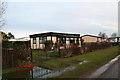
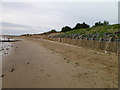
10
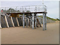
Humberston Beach New Steps to Beach
Image: © JOHN BLAKESTON
Taken: 18 Aug 2011
0.07 miles