IMAGES TAKEN NEAR TO
Townsend Close, GRIMSBY, DN36 4ER
Introduction
This page details the photographs taken nearby to Townsend Close, DN36 4ER by members of the Geograph project.
The Geograph project started in 2005 with the aim of publishing, organising and preserving representative images for every square kilometre of Great Britain, Ireland and the Isle of Man.

There are currently over 7.5m images from over14,400 individuals and you can help contribute to the project by visiting https://www.geograph.org.uk
Image Map
Images are licensed for reuse under creativecommons.org/licenses/by-sa/2.0
Notes
- Clicking on the map will re-center to the selected point.
- The higher the marker number, the further away the image location is from the centre of the postcode.
Image Listing (22 Images Found)
Images are licensed for reuse under creativecommons.org/licenses/by-sa/2.0
Image
Details
Distance
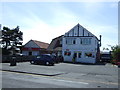
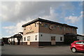
4

The Trawlerman
Popular pub and restaurant near the sea front at Humberston
Image: © Richard Croft
Taken: 5 Jan 2009
0.11 miles
6

Beachcomber on North Sea Lane
Popular for its live music acts.
Image: © Chris
Taken: 3 Mar 2014
0.15 miles
8

Beachcomber Holiday complex at Humberstone
Image: © John Firth
Taken: 8 Jul 2015
0.17 miles