IMAGES TAKEN NEAR TO
Kirkenes Close, GRIMSBY, DN36 4EJ
Introduction
This page details the photographs taken nearby to Kirkenes Close, DN36 4EJ by members of the Geograph project.
The Geograph project started in 2005 with the aim of publishing, organising and preserving representative images for every square kilometre of Great Britain, Ireland and the Isle of Man.

There are currently over 7.5m images from over14,400 individuals and you can help contribute to the project by visiting https://www.geograph.org.uk
Image Map (Loading...)


Getting Data...Please wait
Leaflet Map data © OpenStreetMap
Images are licensed for reuse under creativecommons.org/licenses/by-sa/2.0
Notes
- Clicking on the map will re-center to the selected point.
- The higher the marker number, the further away the image location is from the centre of the postcode.
Image Listing (7 Images Found)
Images are licensed for reuse under creativecommons.org/licenses/by-sa/2.0
Image
Details
Distance
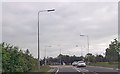
1
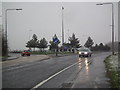
Roundabout on the A16 in a snow storm
On a dark January afternoon.
This is the roundabout just north of Tollbar. The left fork goes to Scartho, the right to Grimsby and Cleethorpes.
Image: © Chris
Taken: 14 Jan 2013
0.07 miles
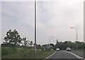
3
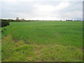
Field near Toll Bar Farm
A green gap between the suburbia of Scartho and New Waltham.
Image: © Jonathan Thacker
Taken: 21 Apr 2012
0.17 miles

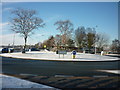
7
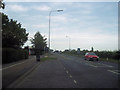
Station Road outside Tollbar School
Viewed from layby outside school looking towards A16
Image: © John Firth
Taken: 11 Jul 2011
0.24 miles