IMAGES TAKEN NEAR TO
Church Avenue, GRIMSBY, DN36 4DR
Introduction
This page details the photographs taken nearby to Church Avenue, DN36 4DR by members of the Geograph project.
The Geograph project started in 2005 with the aim of publishing, organising and preserving representative images for every square kilometre of Great Britain, Ireland and the Isle of Man.

There are currently over 7.5m images from over14,400 individuals and you can help contribute to the project by visiting https://www.geograph.org.uk
Image Map
Images are licensed for reuse under creativecommons.org/licenses/by-sa/2.0
Notes
- Clicking on the map will re-center to the selected point.
- The higher the marker number, the further away the image location is from the centre of the postcode.
Image Listing (20 Images Found)
Images are licensed for reuse under creativecommons.org/licenses/by-sa/2.0
Image
Details
Distance
1
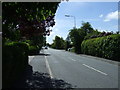
Church Avenue (A1031), heading south
Towards Mablethorpe.
Image: © JThomas
Taken: 25 May 2013
0.14 miles
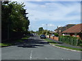
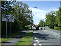
4
Bend in road in Humberstone
Looking south, the church can be seen
Image: © John Firth
Taken: 14 Jun 2012
0.20 miles
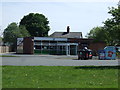
5
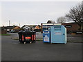
Humberston Library and Recycling Point
Image: © Alan Heardman
Taken: 29 Nov 2009
0.21 miles
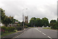
7
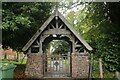
Lychgate and interesting brickwork, St Peter's Church, Humberston (1)
Image: © Chris
Taken: 1 Oct 2023
0.21 miles
8
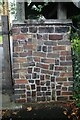
Lychgate and interesting brickwork, St Peter's Church, Humberston (4)
Image: © Chris
Taken: 1 Oct 2023
0.21 miles
9
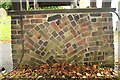
Lychgate and interesting brickwork, St Peter's Church, Humberston (3)
Image: © Chris
Taken: 1 Oct 2023
0.21 miles
10
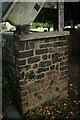
Lychgate and interesting brickwork, St Peter's Church, Humberston (2)
Image: © Chris
Taken: 1 Oct 2023
0.21 miles