IMAGES TAKEN NEAR TO
Trinity Road, CLEETHORPES, DN35 8UQ
Introduction
This page details the photographs taken nearby to Trinity Road, DN35 8UQ by members of the Geograph project.
The Geograph project started in 2005 with the aim of publishing, organising and preserving representative images for every square kilometre of Great Britain, Ireland and the Isle of Man.

There are currently over 7.5m images from over14,400 individuals and you can help contribute to the project by visiting https://www.geograph.org.uk
Image Map (Loading...)


Getting Data...Please wait
Leaflet Map data © OpenStreetMap
Images are licensed for reuse under creativecommons.org/licenses/by-sa/2.0
Notes
- Clicking on the map will re-center to the selected point.
- The higher the marker number, the further away the image location is from the centre of the postcode.
Image Listing (11 Images Found)
Images are licensed for reuse under creativecommons.org/licenses/by-sa/2.0
Image
Details
Distance
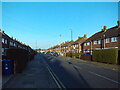
1
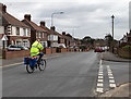
Trinity Road, Cleethorpes
Junction with Thornton Crescent.
Image: © David P Howard
Taken: 7 Mar 2016
0.04 miles
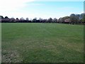
5
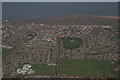
Thrunscoe, one of the Thorpes of Clee: aerial 2016
Image: © Chris
Taken: 19 Apr 2016
0.19 miles
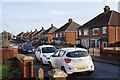
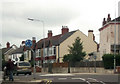
6
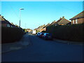
Rufford Road, Cleethorpes
Off Newstead Road.
Image: © Richard Vince
Taken: 24 Feb 2024
0.22 miles
7
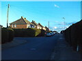
Newstead Road, Cleethorpes
At its junction with Rufford Road (left).
Image: © Richard Vince
Taken: 24 Feb 2024
0.23 miles
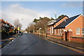
9
Sandringham Road, Cleethorpes (3)
Looking towards the town centre from its junction with Newstead Road.
Image: © Richard Vince
Taken: 24 Feb 2024
0.23 miles
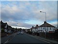
10
Thrunscoe Road junction from Queens Parade
Image: © John Firth
Taken: 16 Jun 2012
0.25 miles