IMAGES TAKEN NEAR TO
Marlborough Way, CLEETHORPES, DN35 0TR
Introduction
This page details the photographs taken nearby to Marlborough Way, DN35 0TR by members of the Geograph project.
The Geograph project started in 2005 with the aim of publishing, organising and preserving representative images for every square kilometre of Great Britain, Ireland and the Isle of Man.

There are currently over 7.5m images from over14,400 individuals and you can help contribute to the project by visiting https://www.geograph.org.uk
Image Map (Loading...)


Getting Data...Please wait
Leaflet Map data © OpenStreetMap
Images are licensed for reuse under creativecommons.org/licenses/by-sa/2.0
Notes
- Clicking on the map will re-center to the selected point.
- The higher the marker number, the further away the image location is from the centre of the postcode.
Image Listing (20 Images Found)
Images are licensed for reuse under creativecommons.org/licenses/by-sa/2.0
Image
Details
Distance
1
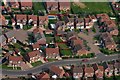
Cleethorpes Aerial Junction Primrose Way Harewood Grove
Taken from 1500ft
Image: © JOHN BLAKESTON
Taken: 18 May 2004
0.06 miles
2
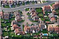
Aerial Cleethorpes Harewood Grove
Taken from 1500 ft
Image: © JOHN BLAKESTON
Taken: 18 May 2004
0.07 miles
3
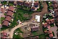
Aerial View Cleethorpes Goodwood Lane
Image: © JOHN BLAKESTON
Taken: 18 May 2004
0.09 miles
4
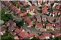
Aerial Cleethorpes Junction Primrose Way Violet Close
Taken from 1500ft
Image: © JOHN BLAKESTON
Taken: 18 May 2004
0.12 miles
5
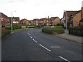
Cleethorpes Country Park Estate
Modern housing on the approach road to Cleethorpes Country Park.
Image: © Roger Gilbertson
Taken: 4 Jan 2007
0.13 miles
6
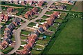
Aerial View Cleethorpes Country Park
Taken from 1500 ft
Image: © JOHN BLAKESTON
Taken: 18 May 2004
0.16 miles
7
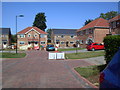
Benjamin's Walk.
Another back garden "land grab" development.
Image: © Robert Reynolds
Taken: 9 Aug 2010
0.17 miles
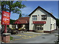
9
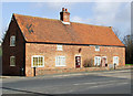
Humberston Road, Cleethorpes
A late 17th, early 18th century house, now a pair. Tumbled Brickwork on the Gable Ends indicate original Thatch Roof now replaced with Pantiles. Note the new brickwork to the upper floor and Yorkshire Sash Windows. This is a Grade II Listed Building.
http://www.flickr.com/photos/riffraff1/3324831191/
Image: © David Hebb
Taken: 25 Mar 2009
0.18 miles
10
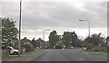
Coniston Crescent junction off Humberston Road
Image: © John Firth
Taken: 10 Jun 2013
0.18 miles