IMAGES TAKEN NEAR TO
Larch Road, CLEETHORPES, DN35 0RW
Introduction
This page details the photographs taken nearby to Larch Road, DN35 0RW by members of the Geograph project.
The Geograph project started in 2005 with the aim of publishing, organising and preserving representative images for every square kilometre of Great Britain, Ireland and the Isle of Man.

There are currently over 7.5m images from over14,400 individuals and you can help contribute to the project by visiting https://www.geograph.org.uk
Image Map
Images are licensed for reuse under creativecommons.org/licenses/by-sa/2.0
Notes
- Clicking on the map will re-center to the selected point.
- The higher the marker number, the further away the image location is from the centre of the postcode.
Image Listing (6 Images Found)
Images are licensed for reuse under creativecommons.org/licenses/by-sa/2.0
Image
Details
Distance
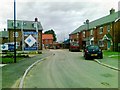
1
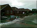
Fernie Place, Cleethorpes
New housing development.
Image: © Alex McGregor
Taken: 14 Dec 2010
0.13 miles
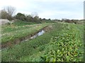
3
Belvoir Road
At Hollingsworth Close, Cleethorpes.
Image: © Roger Gilbertson
Taken: 4 Jan 2007
0.20 miles
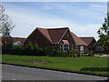
5
New houses, Cottesmore Road, Cleethorpes
Image: © Alex McGregor
Taken: 27 Jun 2012
0.22 miles
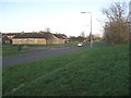
6
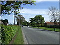
Taylor's Avenue (A1098)
Towards Cleethorpes.
Image: © JThomas
Taken: 25 May 2013
0.22 miles