IMAGES TAKEN NEAR TO
Westbury Park, CLEETHORPES, DN35 0QT
Introduction
This page details the photographs taken nearby to Westbury Park, DN35 0QT by members of the Geograph project.
The Geograph project started in 2005 with the aim of publishing, organising and preserving representative images for every square kilometre of Great Britain, Ireland and the Isle of Man.

There are currently over 7.5m images from over14,400 individuals and you can help contribute to the project by visiting https://www.geograph.org.uk
Image Map (Loading...)


Getting Data...Please wait
Leaflet Map data © OpenStreetMap
Images are licensed for reuse under creativecommons.org/licenses/by-sa/2.0
Notes
- Clicking on the map will re-center to the selected point.
- The higher the marker number, the further away the image location is from the centre of the postcode.
Image Listing (6 Images Found)
Images are licensed for reuse under creativecommons.org/licenses/by-sa/2.0
Image
Details
Distance
3
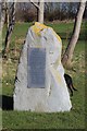
Remembrance Stone, Cleethorpes Country Park
Found at the main entrance to the Country Park the plaque lists names of those involved in the 'foundation' of the park.
Image: © Mandy Clegg
Taken: 9 Mar 2017
0.23 miles
4
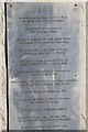
Plaque on Remembrance Stone
Detail of the plaque on the Remembrance Stone at entrance to Cleethorpes Country Park.
Image: © Mandy Clegg
Taken: 9 Mar 2017
0.23 miles

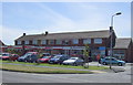
6
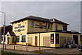
The Coach House
Formerly Fieldhouse Farm. This has been a pub for a long time now. It is however one of the key farmhouses which made up the Carrington estate in the nineteenth century.
Image: © Jon Holland
Taken: 3 Apr 2008
0.25 miles