IMAGES TAKEN NEAR TO
Taylors Avenue, CLEETHORPES, DN35 0LQ
Introduction
This page details the photographs taken nearby to Taylors Avenue, DN35 0LQ by members of the Geograph project.
The Geograph project started in 2005 with the aim of publishing, organising and preserving representative images for every square kilometre of Great Britain, Ireland and the Isle of Man.

There are currently over 7.5m images from over14,400 individuals and you can help contribute to the project by visiting https://www.geograph.org.uk
Image Map
Images are licensed for reuse under creativecommons.org/licenses/by-sa/2.0
Notes
- Clicking on the map will re-center to the selected point.
- The higher the marker number, the further away the image location is from the centre of the postcode.
Image Listing (8 Images Found)
Images are licensed for reuse under creativecommons.org/licenses/by-sa/2.0
Image
Details
Distance
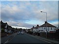
2
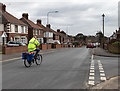
Trinity Road, Cleethorpes
Junction with Thornton Crescent.
Image: © David P Howard
Taken: 7 Mar 2016
0.12 miles
3
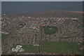
Thrunscoe, one of the Thorpes of Clee: aerial 2016
Image: © Chris
Taken: 19 Apr 2016
0.13 miles
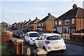
6
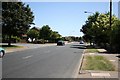
Chichester Road, Cleethorpes
Smart residential area of Cleethorpes
Image: © Richard Croft
Taken: 13 Jul 2006
0.17 miles
7
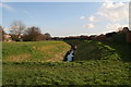
Tributary of Buck Beck emerging from underground by Caenby Road
Leading towards Cleethorpes Country Park.
Image: © Chris
Taken: 3 Mar 2014
0.20 miles
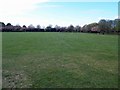
8
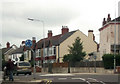
Thrunscoe Road junction from Queens Parade
Image: © John Firth
Taken: 16 Jun 2012
0.25 miles