IMAGES TAKEN NEAR TO
Sherwood Road, GRIMSBY, DN34 5TN
Introduction
This page details the photographs taken nearby to Sherwood Road, DN34 5TN by members of the Geograph project.
The Geograph project started in 2005 with the aim of publishing, organising and preserving representative images for every square kilometre of Great Britain, Ireland and the Isle of Man.

There are currently over 7.5m images from over14,400 individuals and you can help contribute to the project by visiting https://www.geograph.org.uk
Image Map
Images are licensed for reuse under creativecommons.org/licenses/by-sa/2.0
Notes
- Clicking on the map will re-center to the selected point.
- The higher the marker number, the further away the image location is from the centre of the postcode.
Image Listing (7 Images Found)
Images are licensed for reuse under creativecommons.org/licenses/by-sa/2.0
Image
Details
Distance
2
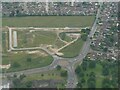
Housing development, B1444/Cambridge Road, Grimsby: aerial 2022 (2)
Image: © Simon Tomson
Taken: 15 Jun 2022
0.17 miles
3
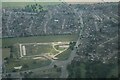
Housing development, B1444/Cambridge Road, Grimsby: aerial 2022 (1)
Image: © Chris
Taken: 15 Jun 2022
0.18 miles
4
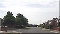
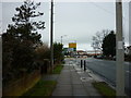
Broadway at junction of St Ives Crescent
Image: © John Firth
Taken: 11 Jun 2013
0.19 miles
6
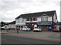
Shops on Little Coates Road at Bradley roundabout
Image: © Martin Dawes
Taken: 29 Apr 2017
0.24 miles
7
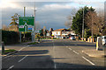
Approaching Bradley Roundabout
Turn right for The Docks,and link to The Humber Bridge, straight on towards Lincoln.
Image: © J.Hannan-Briggs
Taken: 27 Nov 2015
0.24 miles