IMAGES TAKEN NEAR TO
The Close, DONCASTER, DN3 3LX
Introduction
This page details the photographs taken nearby to The Close, DN3 3LX by members of the Geograph project.
The Geograph project started in 2005 with the aim of publishing, organising and preserving representative images for every square kilometre of Great Britain, Ireland and the Isle of Man.

There are currently over 7.5m images from over14,400 individuals and you can help contribute to the project by visiting https://www.geograph.org.uk
Image Map
Images are licensed for reuse under creativecommons.org/licenses/by-sa/2.0
Notes
- Clicking on the map will re-center to the selected point.
- The higher the marker number, the further away the image location is from the centre of the postcode.
Image Listing (3 Images Found)
Images are licensed for reuse under creativecommons.org/licenses/by-sa/2.0
Image
Details
Distance
1
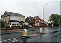
Amenities in Branton
Situated on the B1396 Doncaster Road.
Image: © Jonathan Clitheroe
Taken: 10 May 2016
0.15 miles
2
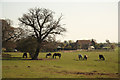
Branton meadow
Horses grazing in a meadow off Brockholes Lane at Branton
Image: © Richard Croft
Taken: 28 Mar 2012
0.23 miles
3
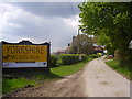
Yorkshire Wildlife Park
Formerly Brockholes Farm.
Image: © steven ruffles
Taken: 11 May 2010
0.24 miles