IMAGES TAKEN NEAR TO
Buckingham Grove, GRIMSBY, DN33 3RR
Introduction
This page details the photographs taken nearby to Buckingham Grove, DN33 3RR by members of the Geograph project.
The Geograph project started in 2005 with the aim of publishing, organising and preserving representative images for every square kilometre of Great Britain, Ireland and the Isle of Man.

There are currently over 7.5m images from over14,400 individuals and you can help contribute to the project by visiting https://www.geograph.org.uk
Image Map (Loading...)


Getting Data...Please wait
Leaflet Map data © OpenStreetMap
Images are licensed for reuse under creativecommons.org/licenses/by-sa/2.0
Notes
- Clicking on the map will re-center to the selected point.
- The higher the marker number, the further away the image location is from the centre of the postcode.
Image Listing (7 Images Found)
Images are licensed for reuse under creativecommons.org/licenses/by-sa/2.0
Image
Details
Distance
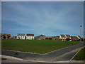
2
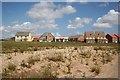
Scartho Top
New homes being built by Redrow at Scartho Top
Image: © Richard Croft
Taken: 31 May 2007
0.08 miles
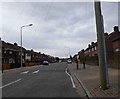
6
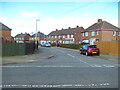
Firsby Crescent, Nunsthorpe
Off Crosby Road.
Image: © Richard Vince
Taken: 24 Feb 2024
0.21 miles