IMAGES TAKEN NEAR TO
Peaks Lane, GRIMSBY, DN32 9ET
Introduction
This page details the photographs taken nearby to Peaks Lane, DN32 9ET by members of the Geograph project.
The Geograph project started in 2005 with the aim of publishing, organising and preserving representative images for every square kilometre of Great Britain, Ireland and the Isle of Man.

There are currently over 7.5m images from over14,400 individuals and you can help contribute to the project by visiting https://www.geograph.org.uk
Image Map
Images are licensed for reuse under creativecommons.org/licenses/by-sa/2.0
Notes
- Clicking on the map will re-center to the selected point.
- The higher the marker number, the further away the image location is from the centre of the postcode.
Image Listing (18 Images Found)
Images are licensed for reuse under creativecommons.org/licenses/by-sa/2.0
Image
Details
Distance
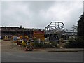
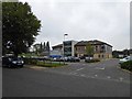
1
The end of the road
The end of Peaks Lane, Grimsby, where it turns into a path.
Image: © Ian S
Taken: 18 Aug 2010
0.04 miles
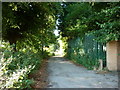
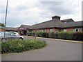
3
Entrance to St Hughs Hospital from Peakes Lane
Image: © John Firth
Taken: 6 Jul 2010
0.08 miles
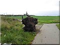
6
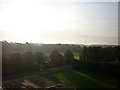
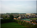
Looking South East
Taken from Peaks Lane Fire Station Tower.
Image: © Ian S
Taken: 22 Sep 2010
0.17 miles
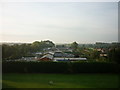
8
Looking South West
Taken from Peaks Lane Fire Station Tower.
Image: © Ian S
Taken: 22 Sep 2010
0.19 miles
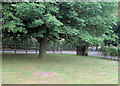
9
Looking South
Taken From Peaks Lane Fire Station Tower.
Image: © Ian S
Taken: 22 Sep 2010
0.19 miles