IMAGES TAKEN NEAR TO
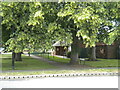
Montrose Avenue, DONCASTER, DN2 6QS
Introduction
This page details the photographs taken nearby to Montrose Avenue, DN2 6QS by members of the Geograph project.
The Geograph project started in 2005 with the aim of publishing, organising and preserving representative images for every square kilometre of Great Britain, Ireland and the Isle of Man.

There are currently over 7.5m images from over14,400 individuals and you can help contribute to the project by visiting https://www.geograph.org.uk
Image Map (Loading...)


Getting Data...Please wait
Leaflet Map data © OpenStreetMap
Images are licensed for reuse under creativecommons.org/licenses/by-sa/2.0
Notes
- Clicking on the map will re-center to the selected point.
- The higher the marker number, the further away the image location is from the centre of the postcode.
Image Listing (17 Images Found)
Images are licensed for reuse under creativecommons.org/licenses/by-sa/2.0
Image
Details
Distance
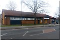
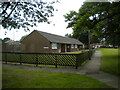
1
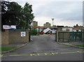
Plover Primary School
As it's half term, workmen are busy lopping trees while the kids are on holiday.
Image: © Oxana Maher
Taken: 29 May 2007
0.06 miles
2
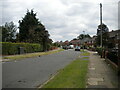
Northumberland Avenue, Intake
Seen from its junction with Grasmere Avenue.
Image: © Richard Vince
Taken: 26 Jun 2021
0.12 miles
3
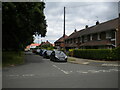
Grasmere Avenue, Intake
Off Northumberland Avenue.
Image: © Richard Vince
Taken: 26 Jun 2021
0.13 miles
4

Copse off Northumberland Avenue, Intake
One of the green spaces that parallels Shaftesbury Avenue, the main distributor road through this part of Intake.
Image: © Richard Vince
Taken: 26 Jun 2021
0.14 miles
6
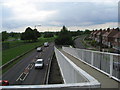
Leger Way
Appropriately named part of the A18 bordering Doncaster racecourse. Lancaster Avenue is the road by the housing estate on the right.
Image: © Oxana Maher
Taken: 29 May 2007
0.16 miles
7
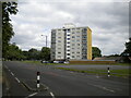
Block of flats off Shaftesbury Avenue, Intake
A fairly modestly dimensioned high rise block.
Image: © Richard Vince
Taken: 26 Jun 2021
0.18 miles
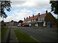
9
Bungalows off Henley Road, Intake
Seen from the footpath to the roundabout at the end of Shaftesbury Avenue.
Image: © Richard Vince
Taken: 26 Jun 2021
0.18 miles
10
Marlow Close footpath, Intake
Linking Shaftesbury Avenue (foreground) with Marlow Road, and providing access to bungalows which are numbered as part of Marlow Close.
Image: © Richard Vince
Taken: 26 Jun 2021
0.19 miles