IMAGES TAKEN NEAR TO
Granby Crescent, DONCASTER, DN2 6AN
Introduction
This page details the photographs taken nearby to Granby Crescent, DN2 6AN by members of the Geograph project.
The Geograph project started in 2005 with the aim of publishing, organising and preserving representative images for every square kilometre of Great Britain, Ireland and the Isle of Man.

There are currently over 7.5m images from over14,400 individuals and you can help contribute to the project by visiting https://www.geograph.org.uk
Image Map (Loading...)


Getting Data...Please wait
Leaflet Map data © OpenStreetMap
Images are licensed for reuse under creativecommons.org/licenses/by-sa/2.0
Notes
- Clicking on the map will re-center to the selected point.
- The higher the marker number, the further away the image location is from the centre of the postcode.
Image Listing (15 Images Found)
Images are licensed for reuse under creativecommons.org/licenses/by-sa/2.0
Image
Details
Distance
2
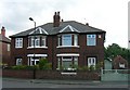
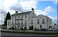
The William Nuttall Cottage Homes
Date from 1930. These were built to house spinsters aged over the age of 50 who had lived in Doncaster for at least 15 years.
Image: © Jonathan Thacker
Taken: 22 Jan 2013
0.08 miles
5
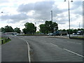
South Parade, Doncaster approaching roundabout
Image: © JThomas
Taken: 24 May 2011
0.16 miles
6
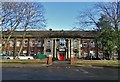
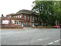
Mary Woollett Centre, Doncaster
The Mary Woollett Professional Development Centre is a fully equipped meeting and training venue situated just outside the centre of Doncaster. It operates under the aegis of Doncaster Council.
Image: © Neil Theasby
Taken: 9 Feb 2020
0.16 miles
7
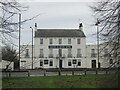
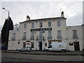
The Grand St Leger hotel.
Bennethorpe, Doncaster.
Image: © steven ruffles
Taken: 18 Jan 2021
0.17 miles
8
Town Field - Doncaster
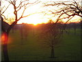
This grid square is dominated by the historic Town Field at the heart of Doncaster. It forms part of the 'Town Moor' area, which includes the town's famous racecourse.
Town Field was officially designated common land in 2004, thereby protecting it from further development. The field is used as playing fields by many local football and rugby teams, and by adjacent primary and secondary schools. This picture was taken from my house on Town Moor Avenue, almost at the southern edge of the field, looking west. The building visible to the left of the setting sun is the Earl of Doncaster hotel on Bennethorpe, immediately beyond the field's boundary. Doncaster's cricket and hockey clubs occupy part of the western edge of Town Field, to the right of the path that can be seen bisecting the field.
There has been considerable controversy over the planting of the new trees that can be seen in the photo, and the removal of many of the old sycamores that flank the southern edge of the field. There are proposals for further planting and landscaping to create zoned seasonal walks, and to include areas with children's play equipment, but again some people feel this will detract from the open common-land character of the field.
Image: © Anthony Heald
Taken: 21 Dec 2004
0.17 miles
9
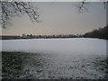
Playing fields, Doncaster School for the Deaf
No sport today.
Image: © Jonathan Thacker
Taken: 22 Jan 2013
0.17 miles