IMAGES TAKEN NEAR TO
Kenmare Crescent, DONCASTER, DN2 5LJ
Introduction
This page details the photographs taken nearby to Kenmare Crescent, DN2 5LJ by members of the Geograph project.
The Geograph project started in 2005 with the aim of publishing, organising and preserving representative images for every square kilometre of Great Britain, Ireland and the Isle of Man.

There are currently over 7.5m images from over14,400 individuals and you can help contribute to the project by visiting https://www.geograph.org.uk
Image Map (7 Images)


Getting Data...Please wait
Leaflet Map data © OpenStreetMap
Images are licensed for reuse under creativecommons.org/licenses/by-sa/2.0
Notes
- Clicking on the map will re-center to the selected point.
- The higher the marker number, the further away the image location is from the centre of the postcode.
Image Listing (7 Images Found)
Images are licensed for reuse under creativecommons.org/licenses/by-sa/2.0
Image
Details
Distance
3
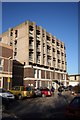
Doncaster Royal Infirmary
Department of Psychiatry at the DRI
Image: © Richard Croft
Taken: 6 Feb 2007
0.16 miles
4
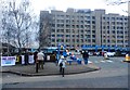
Petitioners Outside Doncaster Royal Infirmary
This group of mainly older members of the community are collecting signatures against the closure of another hospital unit - Bassetlaw Children's Unit in this case.
Image: © Jonathan Clitheroe
Taken: 19 Feb 2017
0.20 miles
5
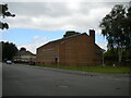
Harvest Fields Ministries, Evelyn Avenue, Intake
A very forbidding looking church whose architecture puts me in mind of a prison.
Image: © Richard Vince
Taken: 26 Jun 2021
0.22 miles
6
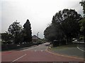
Armthorpe Road / Bruce Crescent Doncaster
In the distance centre left is the chimney at Doncaster hospital.
Image: © Steve Fareham
Taken: 18 Jun 2013
0.24 miles