IMAGES TAKEN NEAR TO
Arklow Road, DONCASTER, DN2 5LE
Introduction
This page details the photographs taken nearby to Arklow Road, DN2 5LE by members of the Geograph project.
The Geograph project started in 2005 with the aim of publishing, organising and preserving representative images for every square kilometre of Great Britain, Ireland and the Isle of Man.

There are currently over 7.5m images from over14,400 individuals and you can help contribute to the project by visiting https://www.geograph.org.uk
Image Map
Images are licensed for reuse under creativecommons.org/licenses/by-sa/2.0
Notes
- Clicking on the map will re-center to the selected point.
- The higher the marker number, the further away the image location is from the centre of the postcode.
Image Listing (8 Images Found)
Images are licensed for reuse under creativecommons.org/licenses/by-sa/2.0
Image
Details
Distance
1
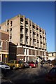
Doncaster Royal Infirmary
Department of Psychiatry at the DRI
Image: © Richard Croft
Taken: 6 Feb 2007
0.09 miles
3
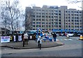
Petitioners Outside Doncaster Royal Infirmary
This group of mainly older members of the community are collecting signatures against the closure of another hospital unit - Bassetlaw Children's Unit in this case.
Image: © Jonathan Clitheroe
Taken: 19 Feb 2017
0.15 miles
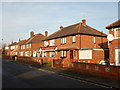
6
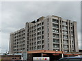
Hospital Block
The main wards of Doncaster Royal Infirmary.
Image: © JENNY BRACK
Taken: 25 Jun 2008
0.18 miles
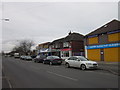
8
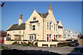
The Cumberland
Popular pub and restaurant opposite Doncaster Royal Infirmary
Image: © Richard Croft
Taken: 6 Feb 2007
0.24 miles