IMAGES TAKEN NEAR TO
Marlborough Road, DONCASTER, DN2 5DF
Introduction
This page details the photographs taken nearby to Marlborough Road, DN2 5DF by members of the Geograph project.
The Geograph project started in 2005 with the aim of publishing, organising and preserving representative images for every square kilometre of Great Britain, Ireland and the Isle of Man.

There are currently over 7.5m images from over14,400 individuals and you can help contribute to the project by visiting https://www.geograph.org.uk
Image Map
Images are licensed for reuse under creativecommons.org/licenses/by-sa/2.0
Notes
- Clicking on the map will re-center to the selected point.
- The higher the marker number, the further away the image location is from the centre of the postcode.
Image Listing (6 Images Found)
Images are licensed for reuse under creativecommons.org/licenses/by-sa/2.0
Image
Details
Distance
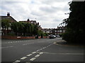
2
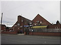
The Intake Social Club, Intake, Doncaster
A Sam Smith's Social Club.
Image: © Ian S
Taken: 25 Feb 2012
0.22 miles
5
North end of Osborne Road, Doncaster
Seen from the end of Victorian Crescent.
Image: © Richard Vince
Taken: 26 Jun 2021
0.25 miles
6

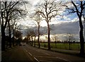
Town Moor Avenue, Doncaster
Tree lined and difficult to photograph.
Image: © Richard Vince
Taken: 26 Jun 2021
0.25 miles