IMAGES TAKEN NEAR TO
Thorne Road, DONCASTER, DN2 5AW
Introduction
This page details the photographs taken nearby to Thorne Road, DN2 5AW by members of the Geograph project.
The Geograph project started in 2005 with the aim of publishing, organising and preserving representative images for every square kilometre of Great Britain, Ireland and the Isle of Man.

There are currently over 7.5m images from over14,400 individuals and you can help contribute to the project by visiting https://www.geograph.org.uk
Image Map
Images are licensed for reuse under creativecommons.org/licenses/by-sa/2.0
Notes
- Clicking on the map will re-center to the selected point.
- The higher the marker number, the further away the image location is from the centre of the postcode.
Image Listing (16 Images Found)
Images are licensed for reuse under creativecommons.org/licenses/by-sa/2.0
Image
Details
Distance
1
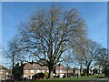
Large tree, Thorne Road, Doncaster
On the amenity grassland at the eastern edge of Wheatley Park.
Image: © Christine Johnstone
Taken: 9 Apr 2022
0.03 miles
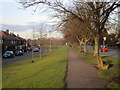
2
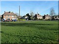
Junction of Coventry Grove and Thorne Road
This large grassy area was part of the original 1940s design of Doncaster's Wheatley Park estate.
Image: © Christine Johnstone
Taken: 9 Apr 2022
0.10 miles
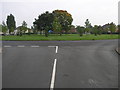
3
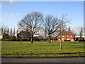
Another amenity area
But an amenity for whom? The planting of trees on this and other similar areas nearby makes them useless for children playing ball games and yet there doesn't seem to be much provision for children elsewhere. My visit coincided with half term and on a (relatively) warm, sunny day children were conspicuous by their absence.
Image: © Jonathan Thacker
Taken: 17 Feb 2015
0.12 miles
4
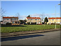
Amenity land
But an amenity for whom? The planting of trees on this and other similar areas nearby makes them useless for children playing ball games and yet there doesn't seem to be much provision for children elsewhere. My visit coincided with half term and on a (relatively) warm, sunny day children were conspicuous by their absence.
Image: © Jonathan Thacker
Taken: 17 Feb 2015
0.13 miles
5
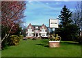
Lawn and Beer Garden at the Wheatley Hotel
Pictured on a fine day in early April. Apart from the left gable end, the pub itself is situated over the line in SE6005.
Image: © Jonathan Clitheroe
Taken: 3 Apr 2017
0.15 miles
6
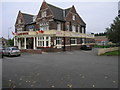
Wheatley Hotel
The Wheatley Hotel sits right by the side of the western edge of this square.
Image: © Michael Patterson
Taken: 16 Oct 2006
0.17 miles
8
Estate Island
This island in the middle of Wheatley Park housing estate has six roads leading off it.
Image: © Michael Patterson
Taken: 16 Oct 2006
0.20 miles
9

Wheatley Retail Park, Doncaster
Some of the shops at the northern end of the park which is still undergoing improvements to parking and walkways
Image: © Paul Harrop
Taken: 15 Jul 2015
0.20 miles
10
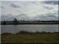
Looking across the canal to the shops at the Wheatley centre.
The buildings on the map have since been demolished.
Image: © steven ruffles
Taken: 15 Mar 2010
0.21 miles