IMAGES TAKEN NEAR TO
Jefferson Avenue, DONCASTER, DN2 4RX
Introduction
This page details the photographs taken nearby to Jefferson Avenue, DN2 4RX by members of the Geograph project.
The Geograph project started in 2005 with the aim of publishing, organising and preserving representative images for every square kilometre of Great Britain, Ireland and the Isle of Man.

There are currently over 7.5m images from over14,400 individuals and you can help contribute to the project by visiting https://www.geograph.org.uk
Image Map (6 Images)


Getting Data...Please wait
Leaflet Map data © OpenStreetMap
Images are licensed for reuse under creativecommons.org/licenses/by-sa/2.0
Notes
- Clicking on the map will re-center to the selected point.
- The higher the marker number, the further away the image location is from the centre of the postcode.
Image Listing (6 Images Found)
Images are licensed for reuse under creativecommons.org/licenses/by-sa/2.0
Image
Details
Distance
1
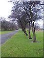
Sandall Park, Doncaster
Taken from the top deck of a bus.
Image: © Ian S
Taken: 4 Aug 2010
0.11 miles
2
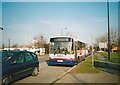
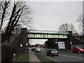
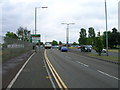
Bus on Barnby Dun Road, Wheatley Hills
First South Yorkshire 60572, a Volvo B10M/Alexander PS, stands in a queue of traffic blocking back from Clay Lane Roundabout while working route 84 to Doncaster town centre. This was Mainline's standard full size bus type for much of the 1990s: it eventually amassed 180 of the type, a significant proportion of the fleet.
Image: © Richard Vince
Taken: 16 Feb 2008
0.17 miles
3
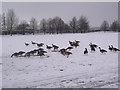
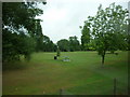
Canada geese at Sandall Park
Canada geese grazing in the snow at Sandall Park.
Image: © Martin Speck
Taken: 7 Feb 2012
0.18 miles